to the total population for the countries/regions. Japan has a ratio roughly equivalent to Malaysia and Nepal. It's about 1/3 the ratio of the United States. Compared to the population ratio in Germany, it's around 1/10 the scale. Around 1/3
how large an area each mapper needs to map. In Japan, with the current number of mappers, it seems that mapping an area of around 3,000 square km would be needed to cover the entire country. This area is close to the ratios of Spain and Greece. However, in terms of the ratio to the total population, Spain and Greece have 3-4 times the mapper ratio compared to Japan. 3 times 4 times
Japan does not have a very large number of mappers relative to its population • The area that each individual mapper needs to cover is quite large, indicating that expansion of the community on a larger scale is needed in this region Note: Of course, this analysis is an overly simplistic “hack”. The mapper numbers should use averaged figures, and factors like the urban population ratio and device ownership rates may also need to be taken into account. This is simply intended as material to grasp general trends.
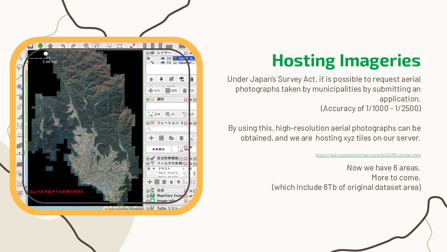
area Operating osm.jp Mainly for event promotions and announcements Coordination Coordinating with other organizations (e.g. Government) Hosting Imageries Hosting the Imageries taken by municipalities (under JP survey act) Inquiries Mainly from commercial use. Replying based on the guidelines
request aerial photographs taken by municipalities by submitting an application. (Accuracy of 1/1000 - 1/2500) By using this, high-resolution aerial photographs can be obtained, and we are hosting xyz tiles on our server. https://wiki.openstreetmap.org/wiki/OSMFJ/ortho-tiles Now we have 6 areas. More to come. (which include 6Tb of original dataset area)
(*)” which normalize administrative datasets. That include maps, addresses and cadastra. It’s massive and useful resources also. * Equivalent to EU: ABR (Access to the Base Registries)
and Tasks Addresses (Urban) Yes Approximately, the schemes match between this and OSM. But need some updates and clarification on OSM side. Addresses (Country) Yes Same above. Cadastra Yes Half of the dataset are stored in arbitrary coordinate system. So it needs huge updates to use. Plateau dataset No Not a base registry precisely. 3D citygml dataset which covers 250 larger cities. Agricultural area (Fude polygon) No Not base registry precisely. Farmlands and rice fields with identifier for whole Japan. License - Our “Open Government License” is UK based. So it need to clarify the compatibility to LWG.
Mappy Hour Held on every saturday night. Online. Over 4 years! Welcome message 2 years of continuous messaging. Thank you OSM be! Mapping Party 1-2 per 2 months. Mainly around Kyoto. Events Promotion on other Open Source Events
night. (over 4 years!) Each participant edits maps and exchange feedbacks. It has greatly contributed to community engagement. Lead User:K_Sakanoshita (OSMFJ Board)
containing attributes that are difficult to survey, including building heights. It covers major metropolitan areas. User:Okadatsuneo Convert script is made by user:yuuhayashi Summary Lead
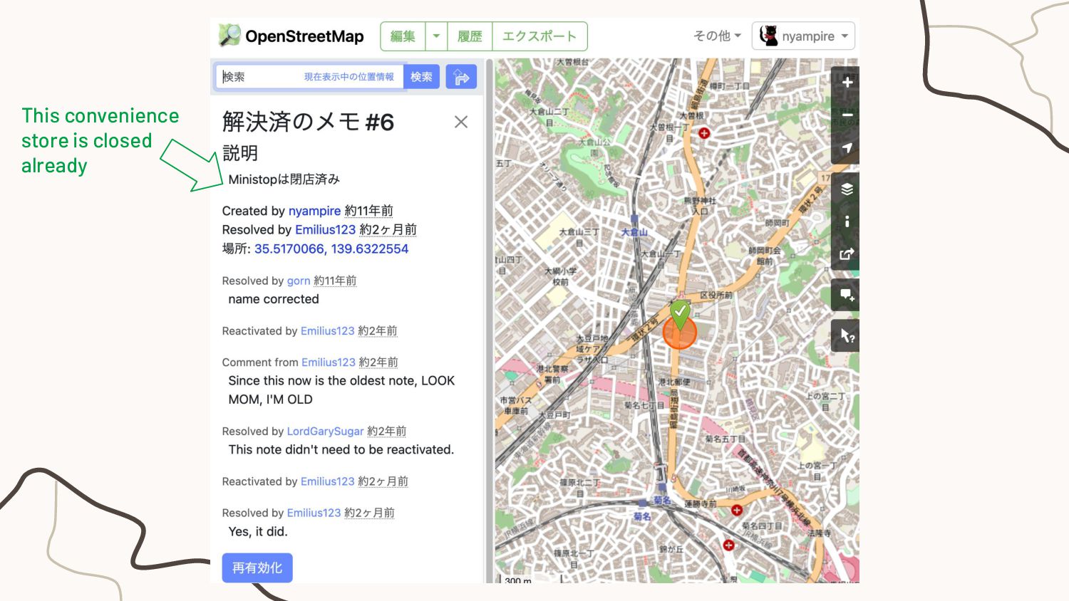
send messages to new users. Continued for 2 years. The response rate was not high, so more proactive outreach may be necessary. (such as responding to review requests) User:nyampire and user:Mappin' Jack Flash Summary Lead
Rather than being business-driven. Issues • There is a tendency for individuals to focus on limited territories (regions/domains). • Improving comprehensiveness, inputting attribute values that are not displayed on the map (such as lanes), etc. are challenges. N S W E
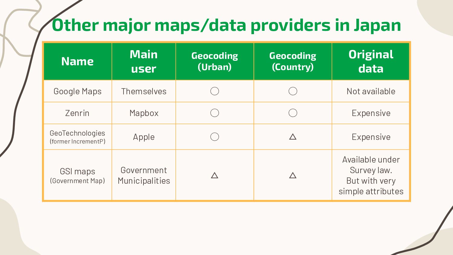
(Urban) Geocoding (Country) Original data Google Maps Themselves ◯ ◯ Not available Zenrin Mapbox ◯ ◯ Expensive GeoTechnologies (former IncrementP) Apple ◯ △ Expensive GSI maps (Government Map) Government Municipalities △ △ Available under Survey law. But with very simple attributes
10% “Maps for 90%” is already there in Japan. So what should be done for the “best maps”? ▪ More valuable for people? ▪ More useful for analysis or research? ▪ To know and to love your city? Keywords could be • Local people, Archives and so on…
Probably less used in the Disaster area. This news says “2000 volunteers creates maps to archive the city”. (interview with Shimizu@HOT Voting member) “By keeping a record of what the original state was, it can help show how to recover and move forward.” On the other hand, OSM data should reflect “Now”. So need update those areas sooner. Maybe it may need a relationship with OHM. https://www.asahi.com/articles/ASS5N4R83S5NPJLB004M.html
the use of Open Source tools e.g. QGIS, MapLibre and so on… For Community members E.g. Suggest new approaches, and/or projects. Hold “Ask me anything about mapping” office hours. Outreach and Relationship Wikipedian? Map lovers? Hikers? NPOs? Teachers? Civic tech?