Upgrade to Pro — share decks privately, control downloads, hide ads and more …

Perspectives on Modern Geoinformatics Concepts ...

Perspectives on Modern Geoinformatics Concepts in Disaster Information

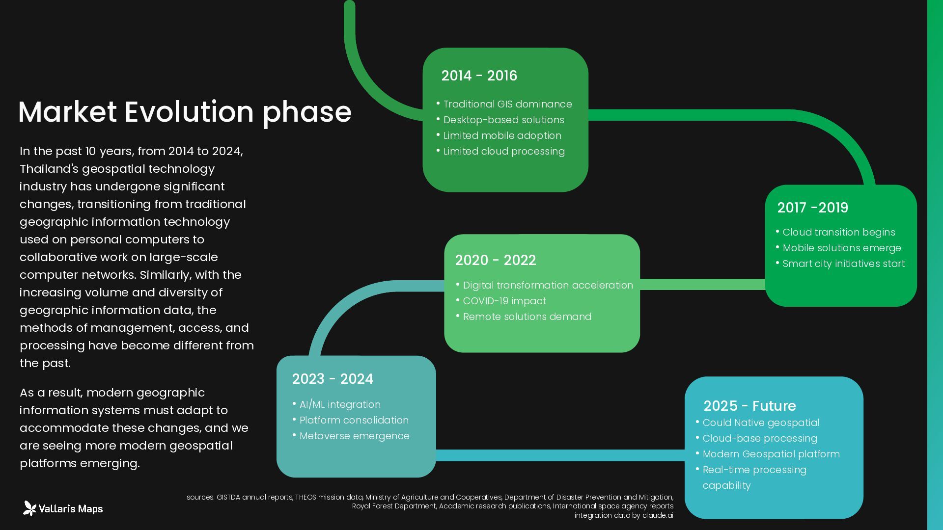
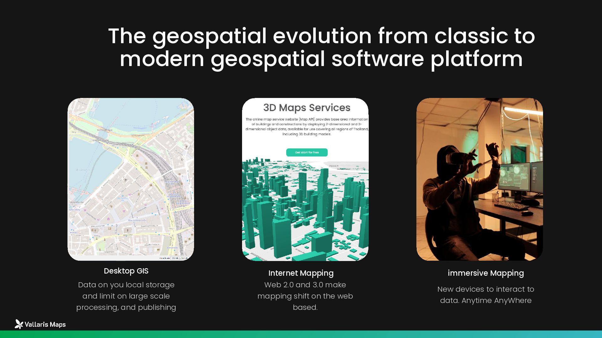
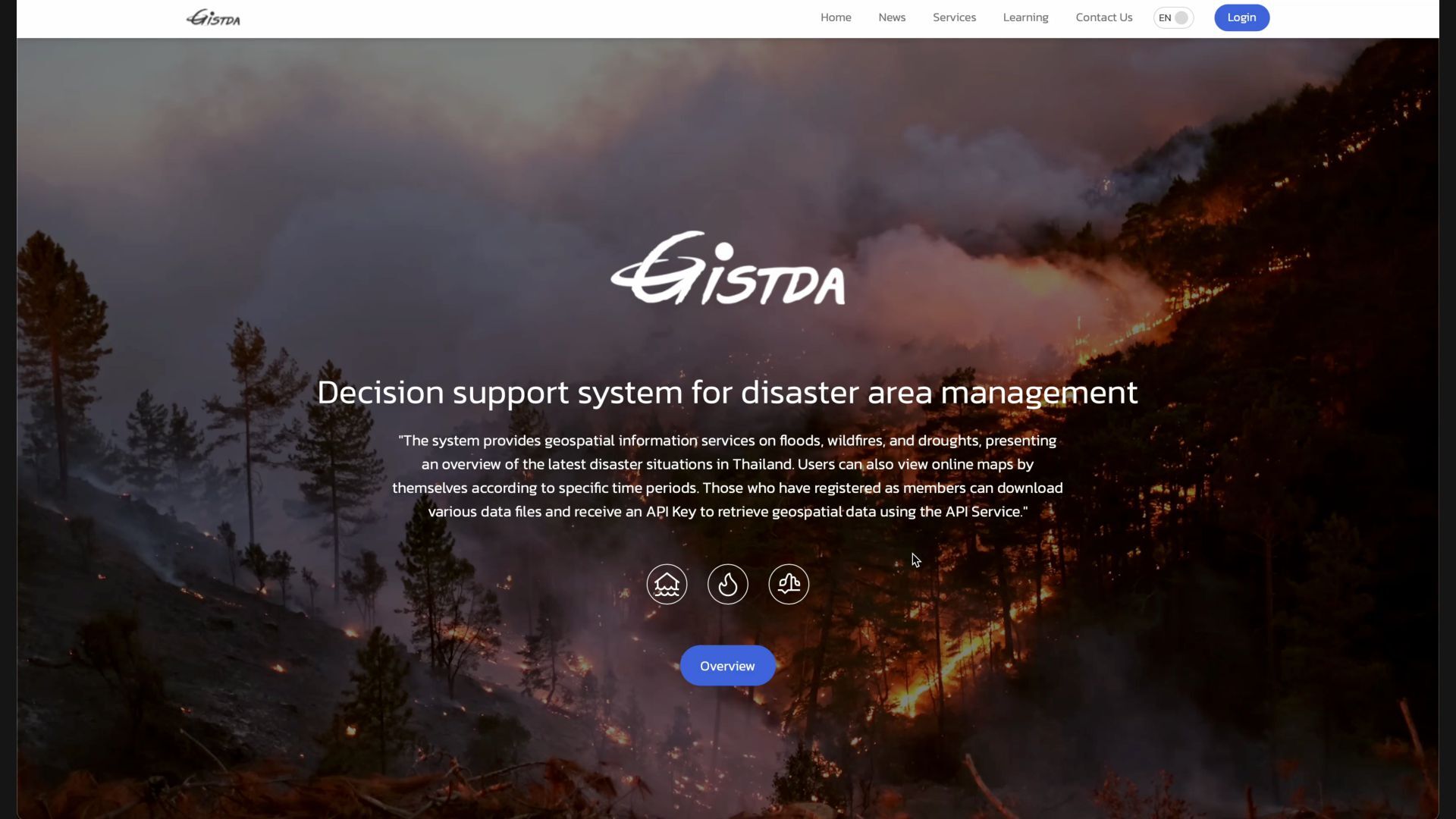
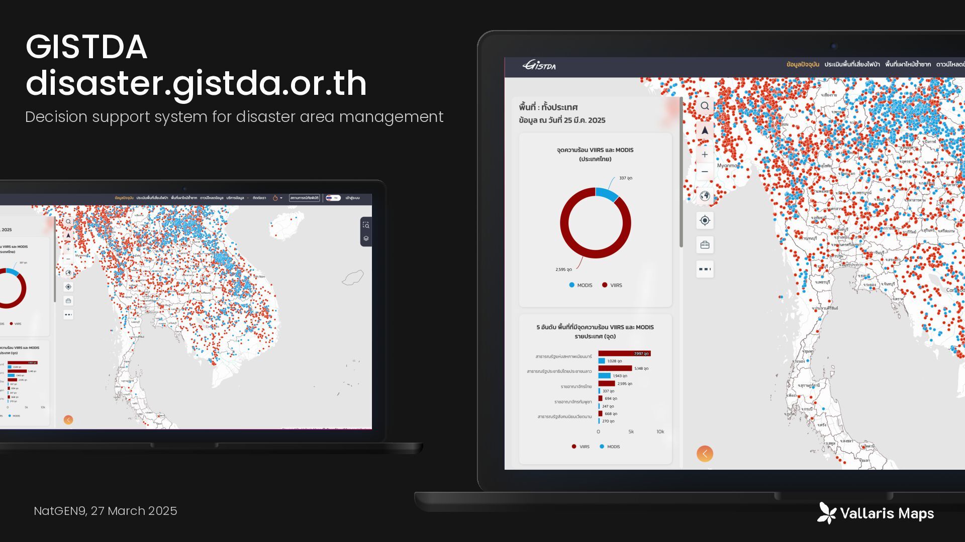
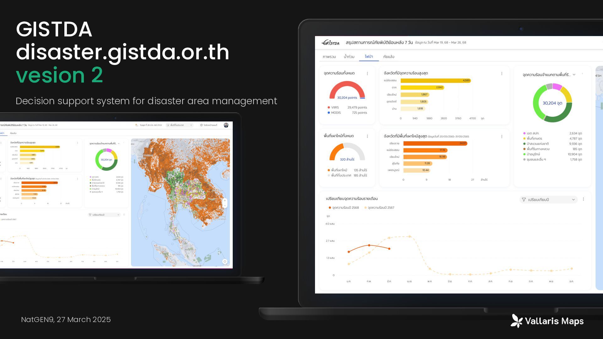
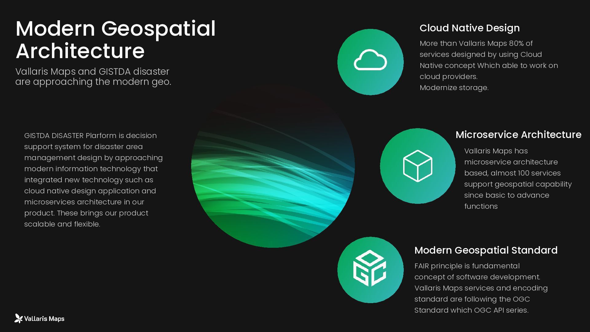
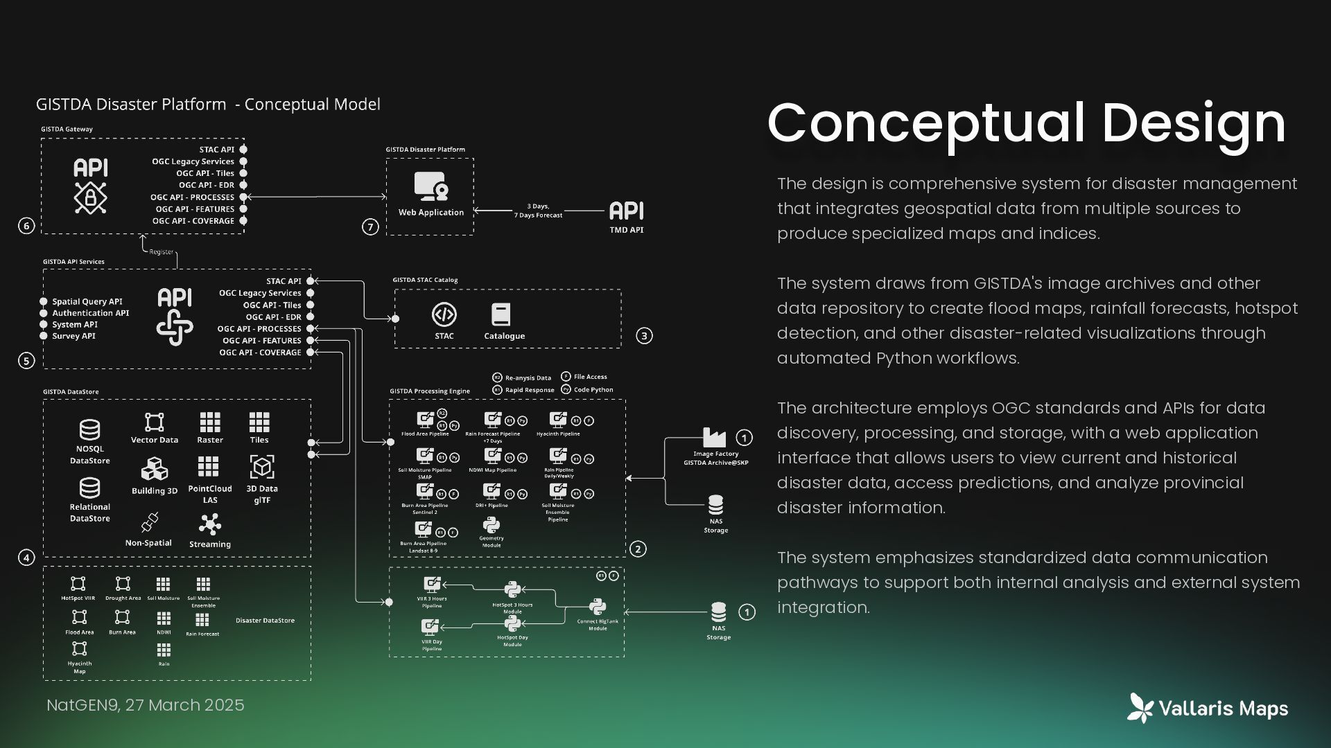
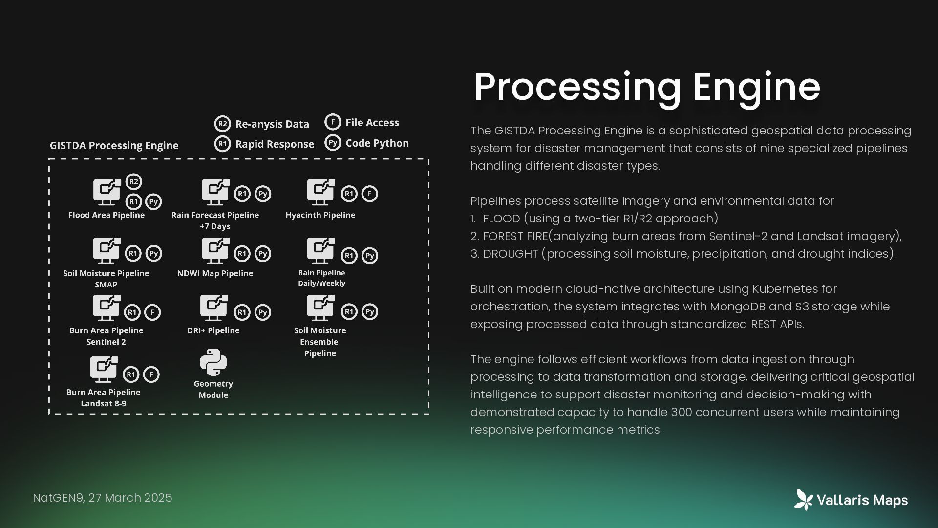
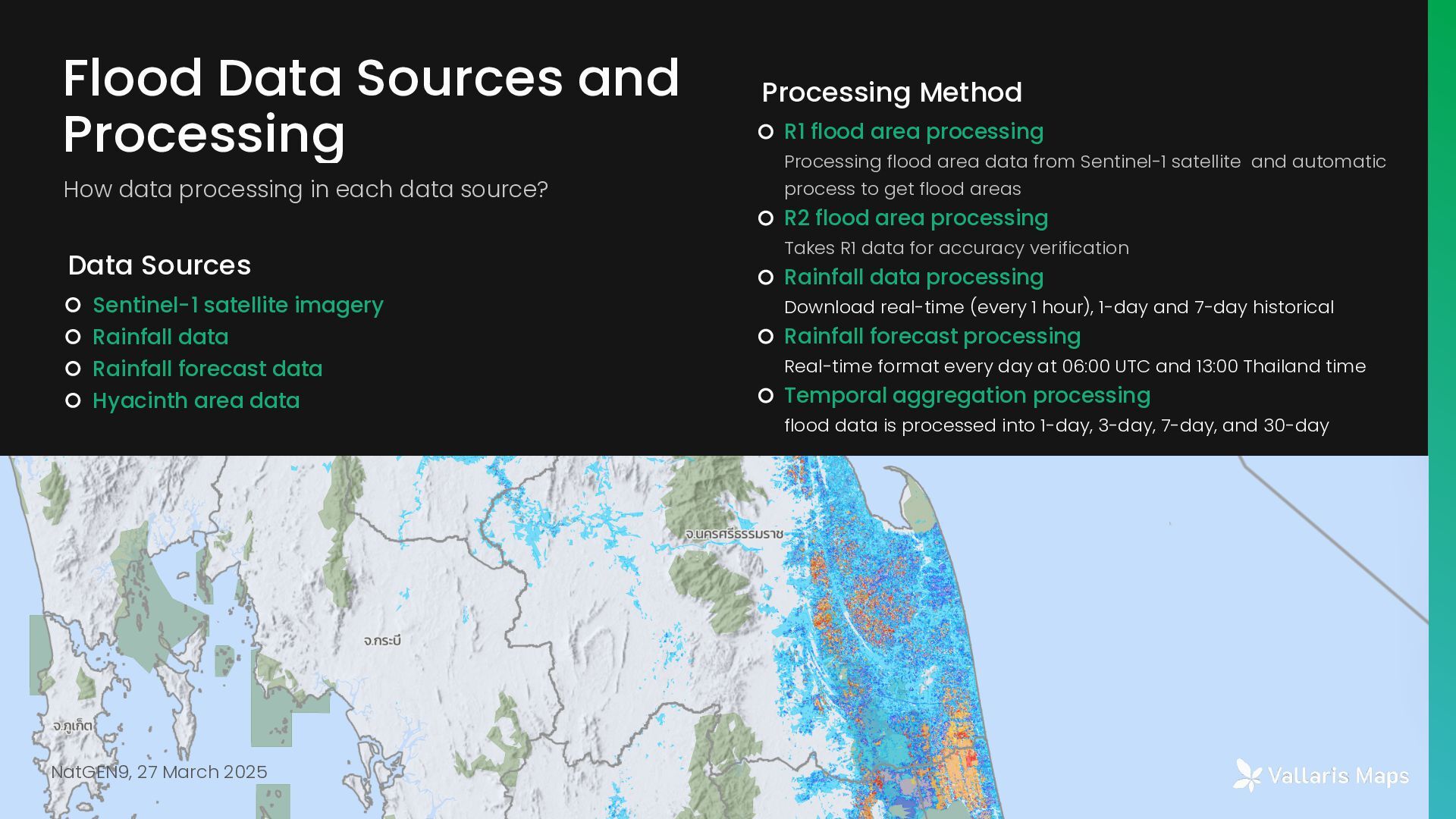
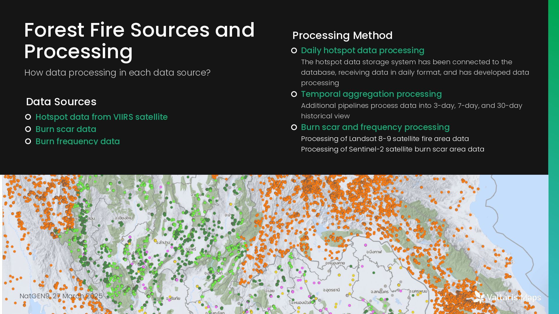
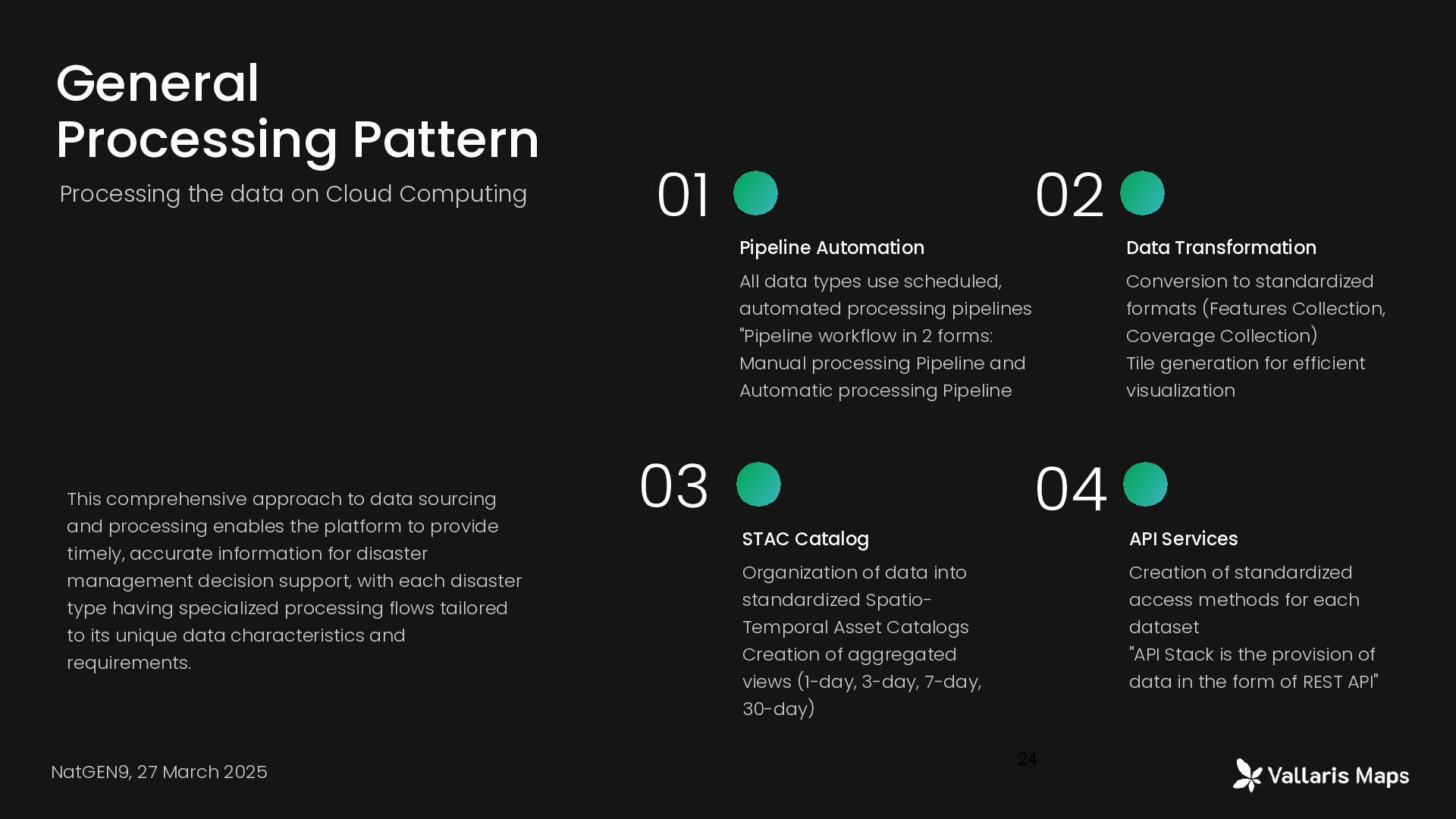
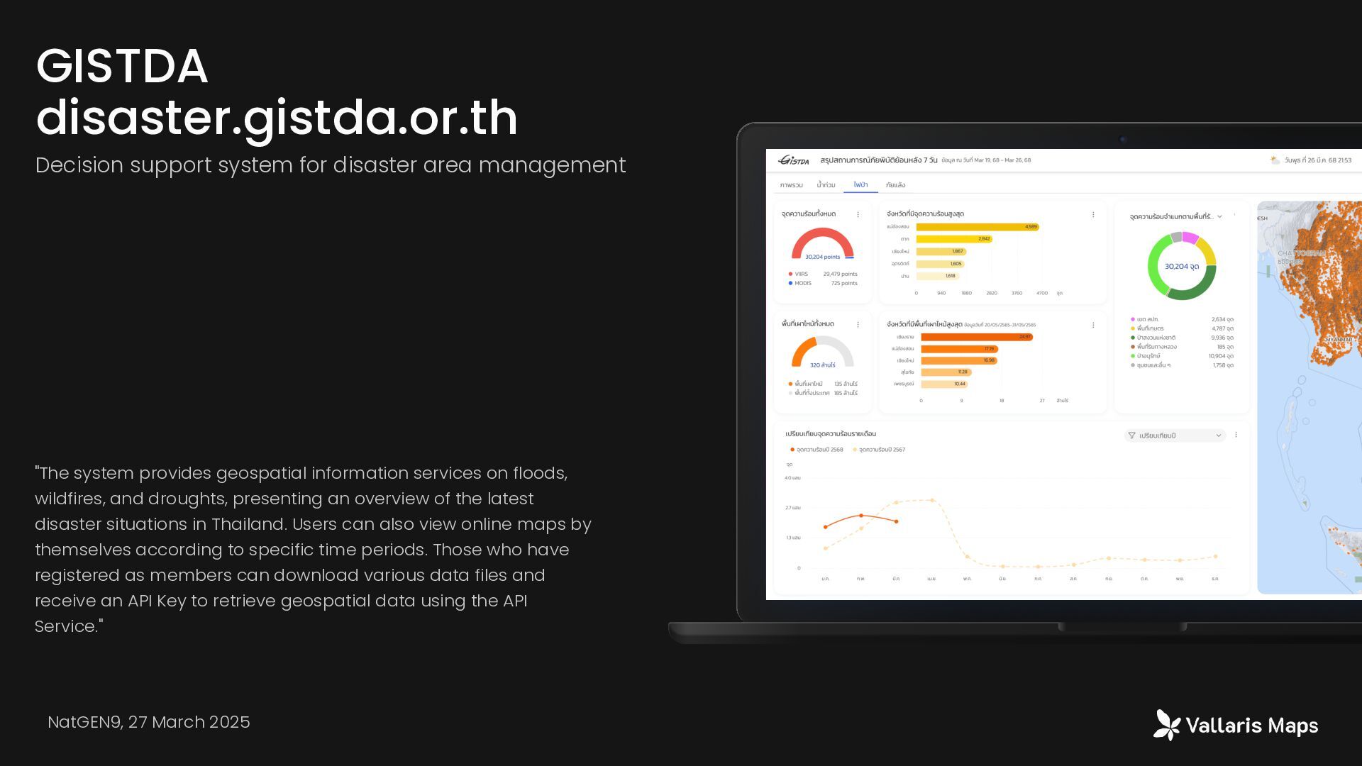
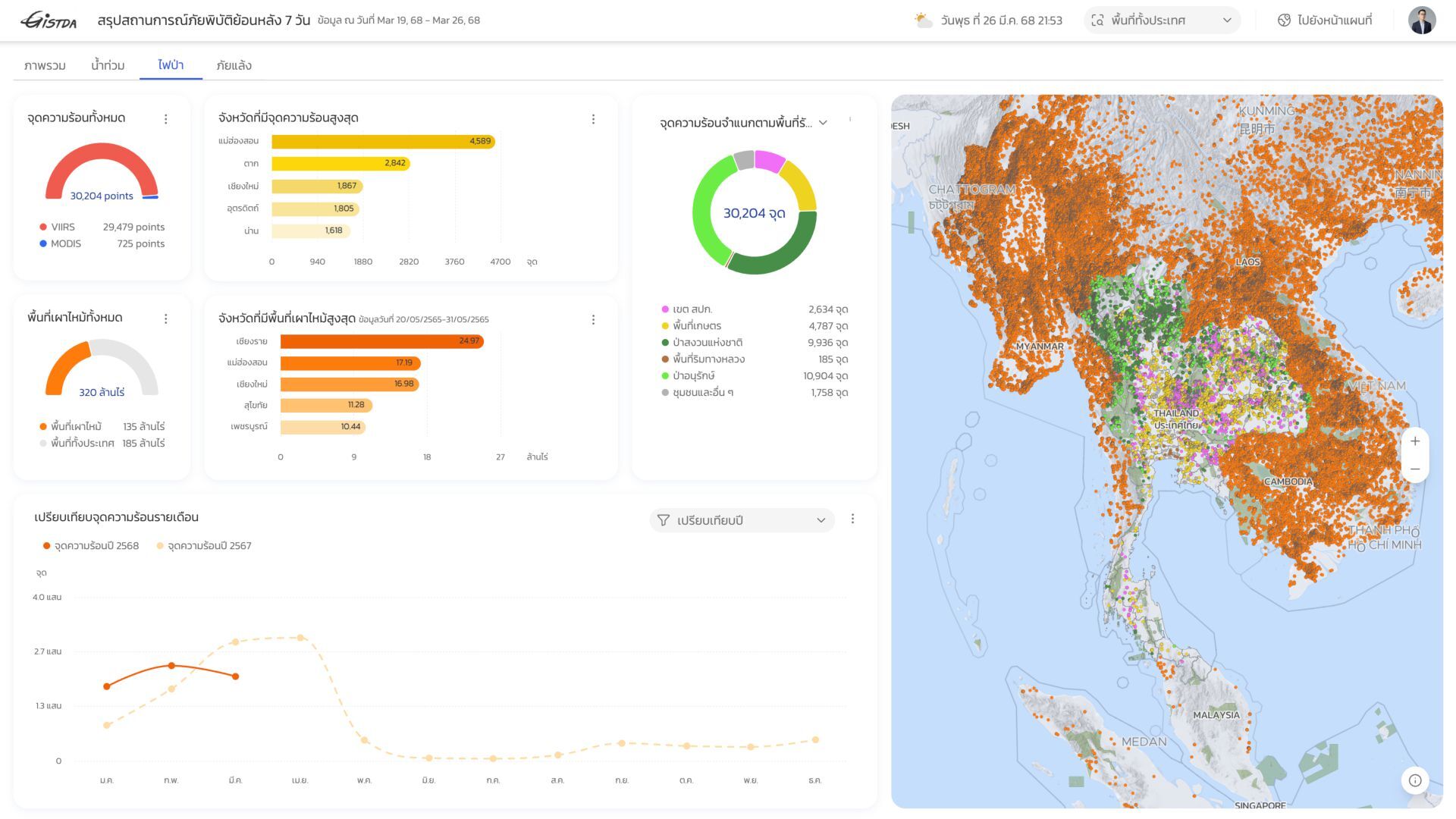
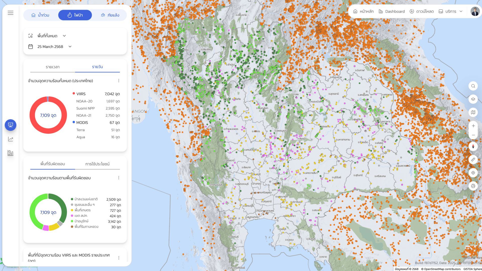
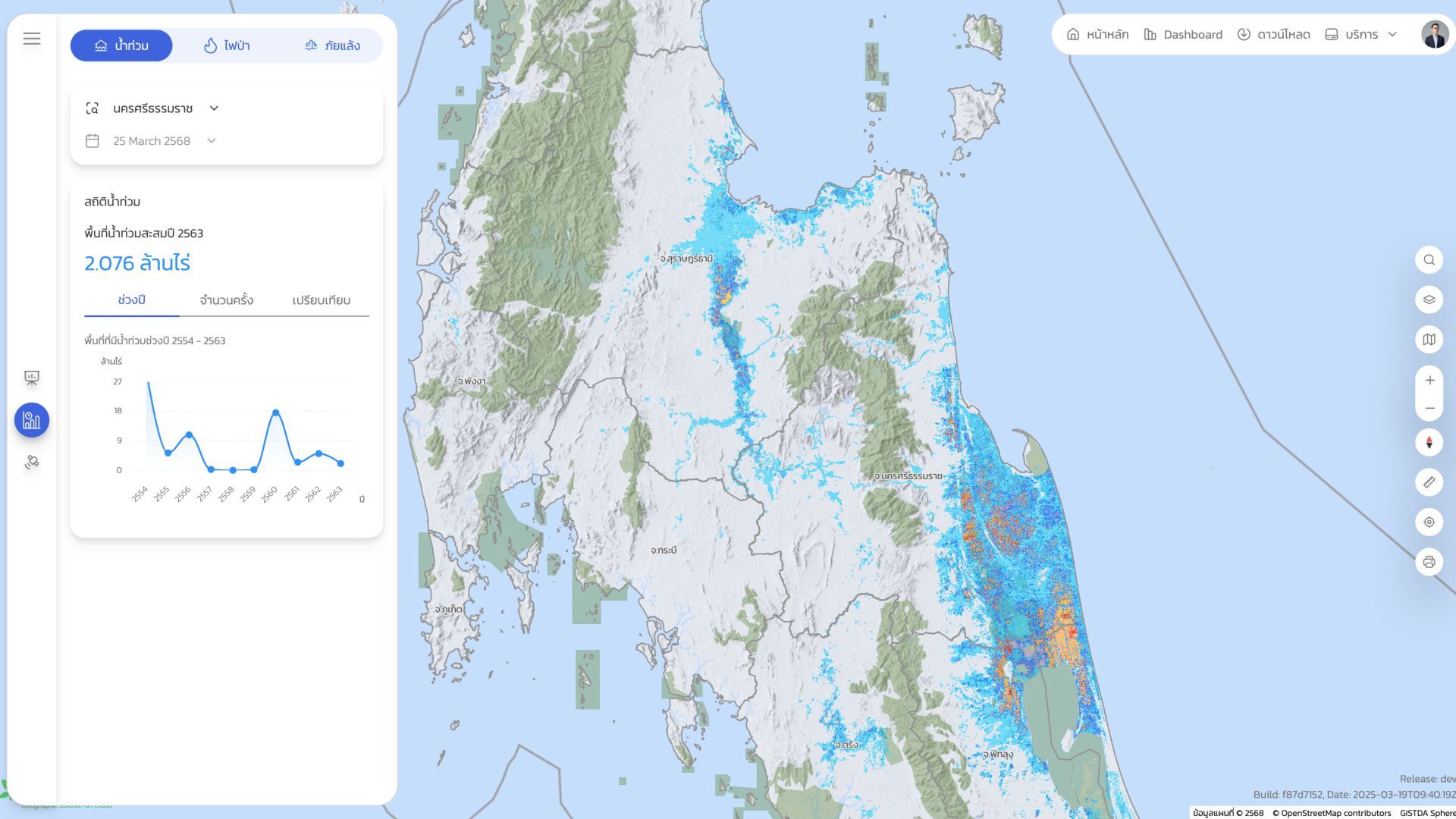
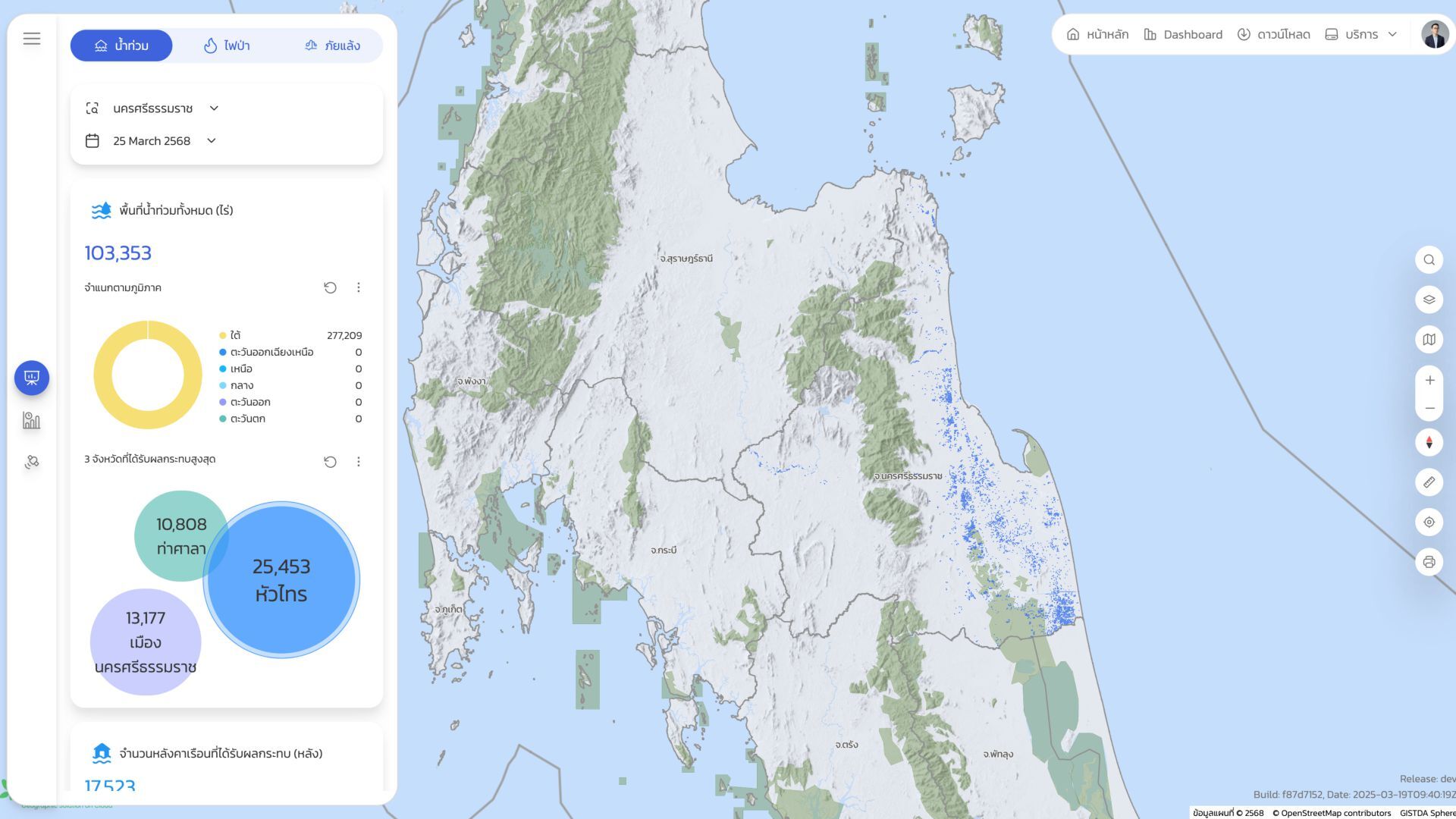
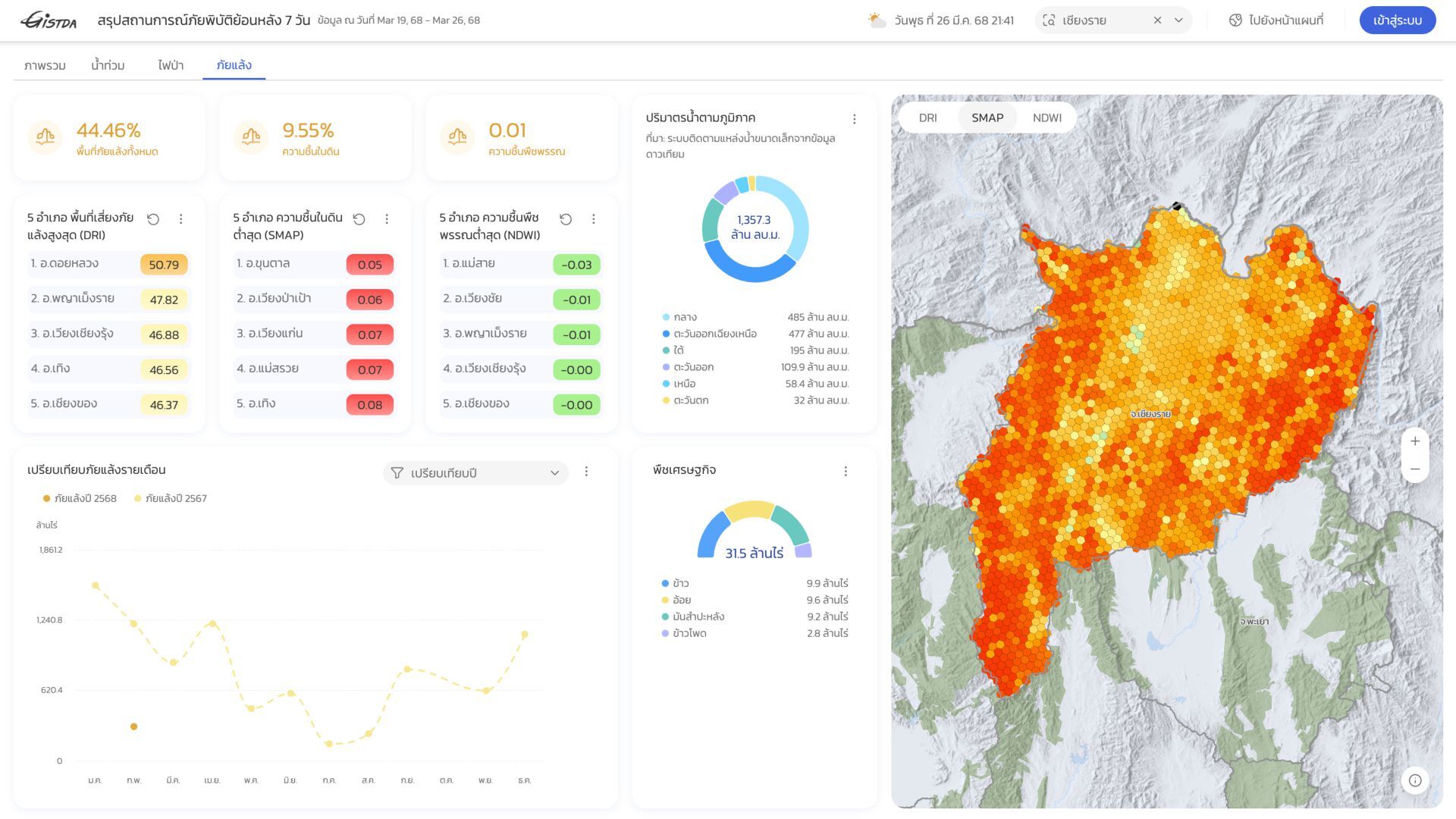
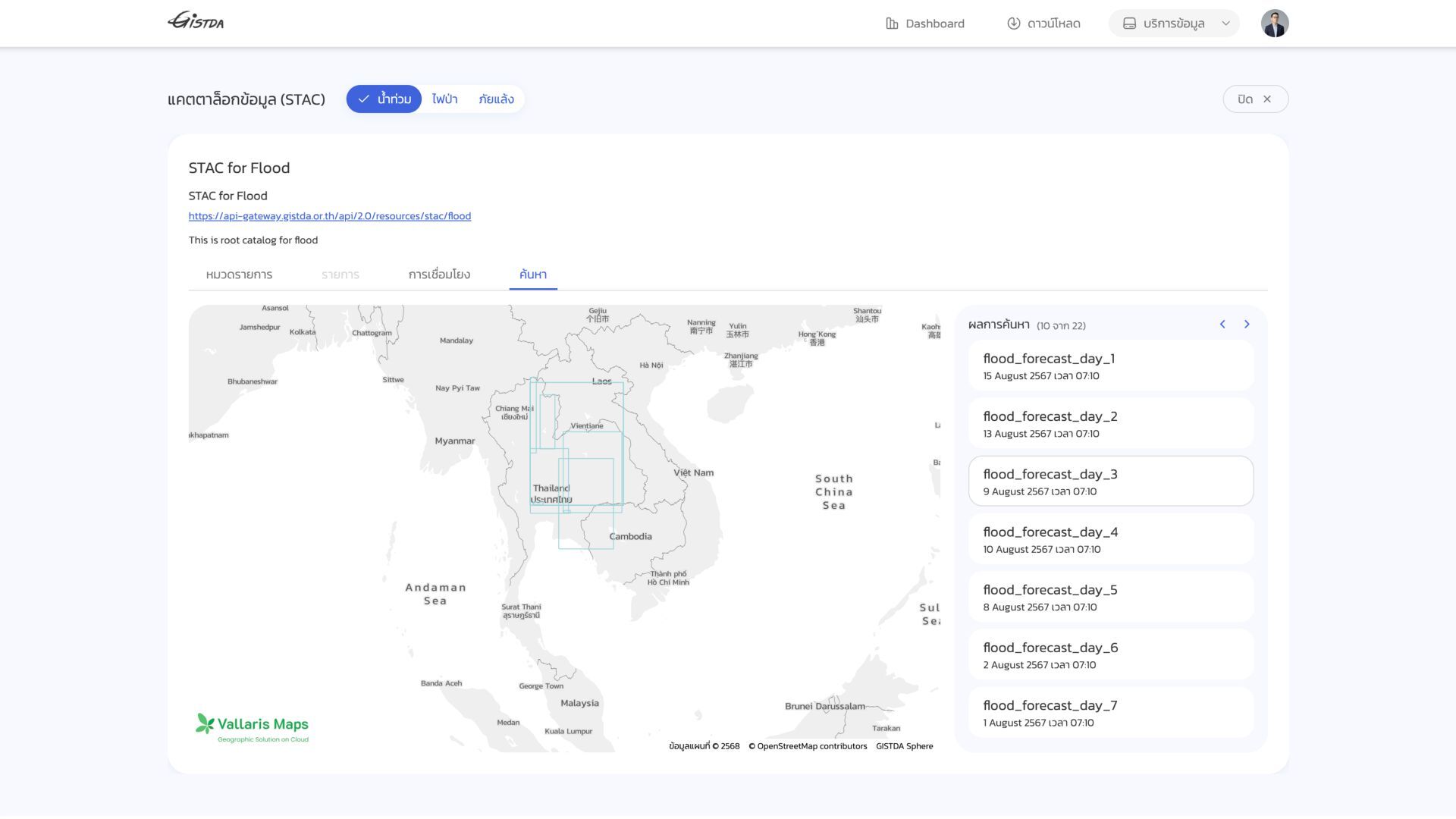
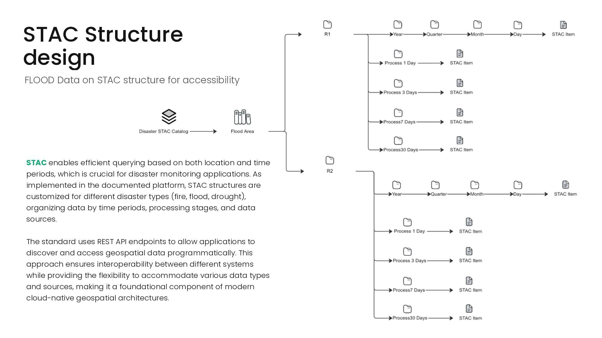
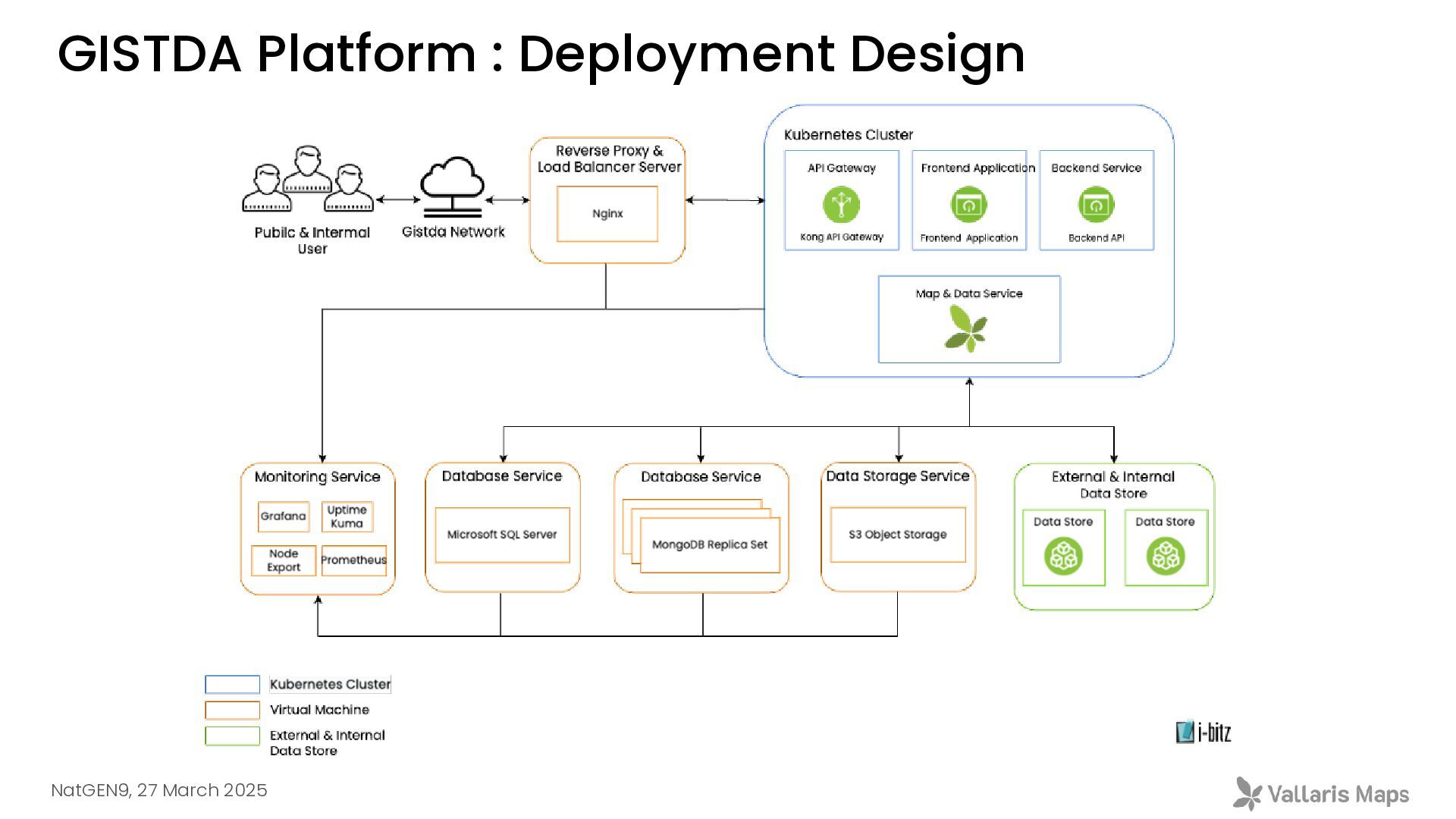
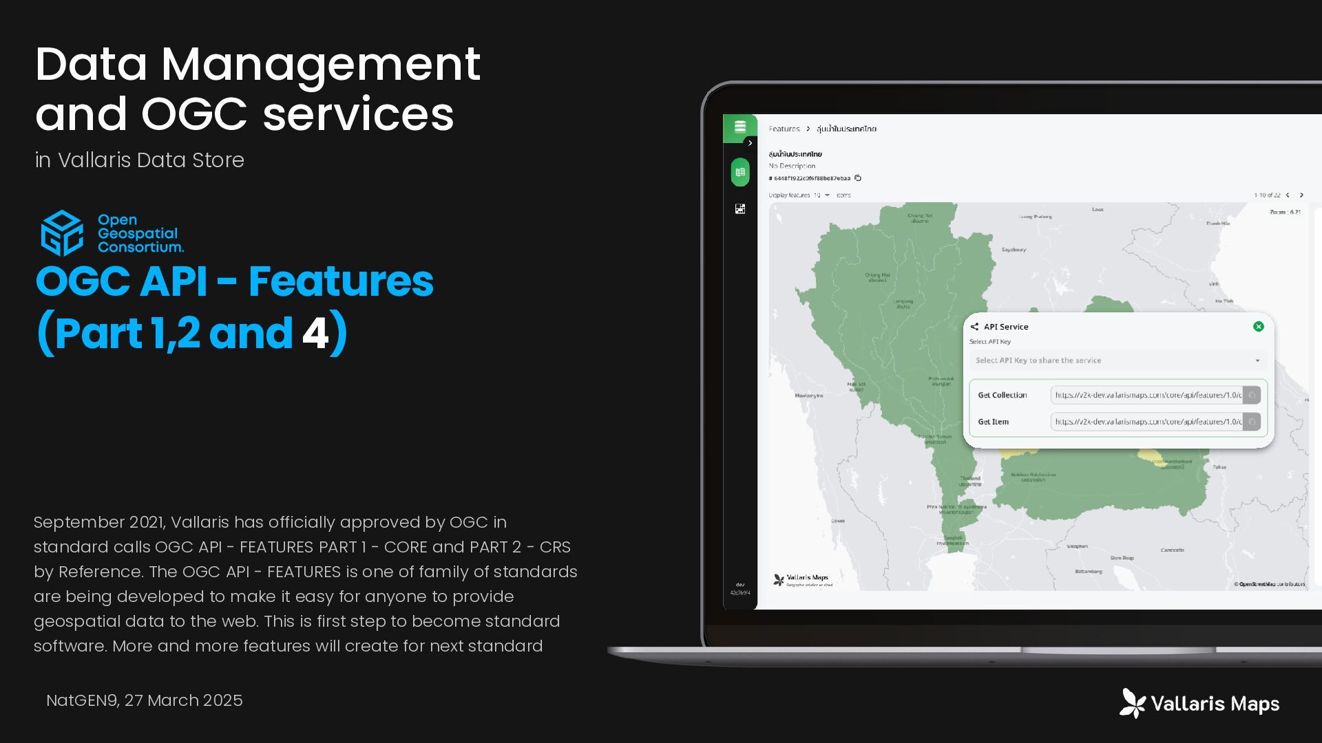
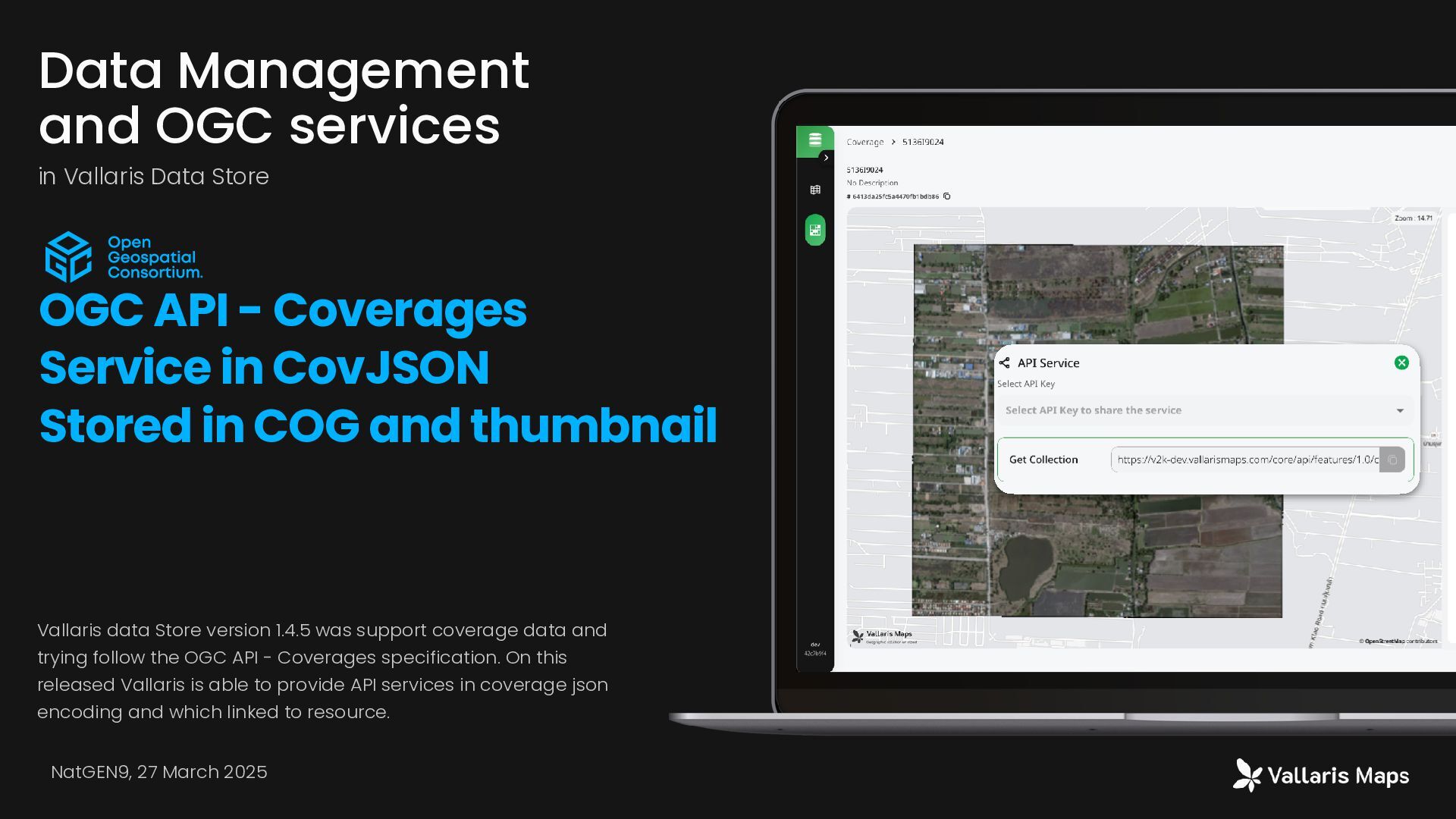
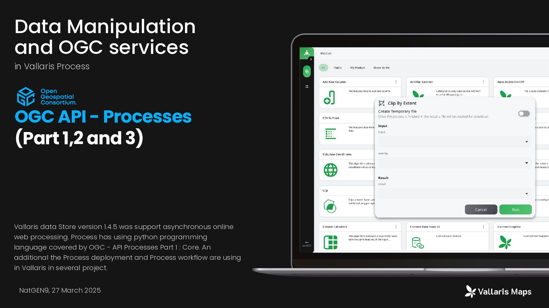
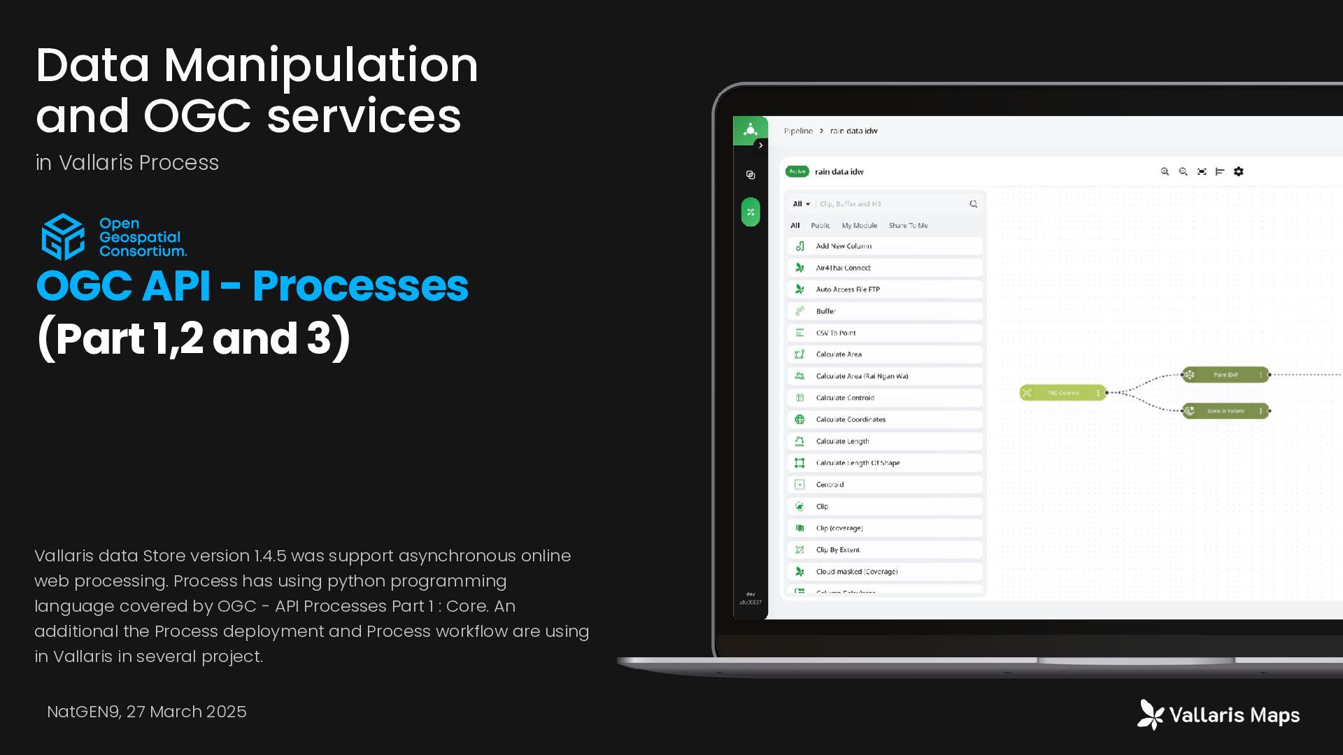
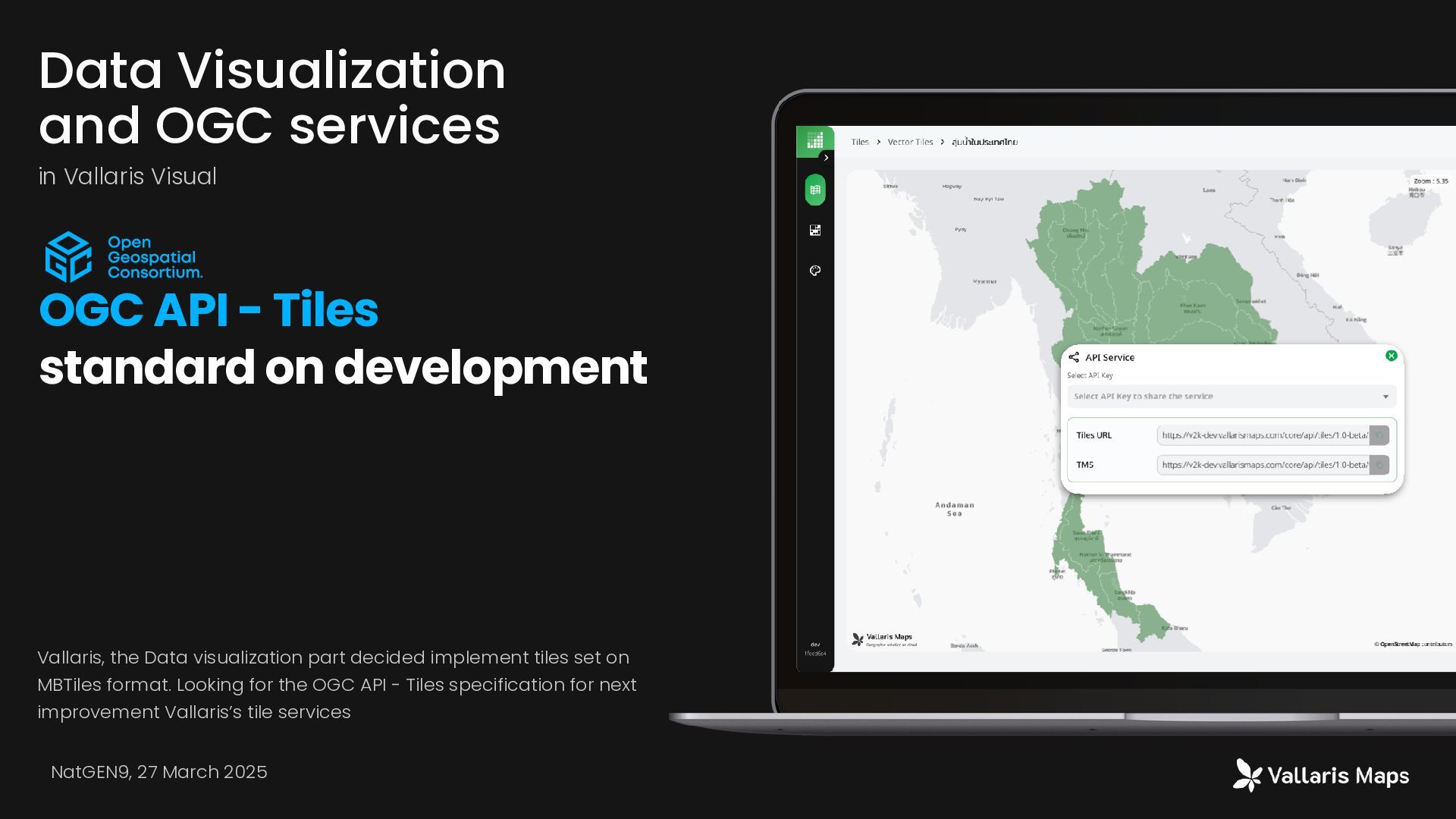
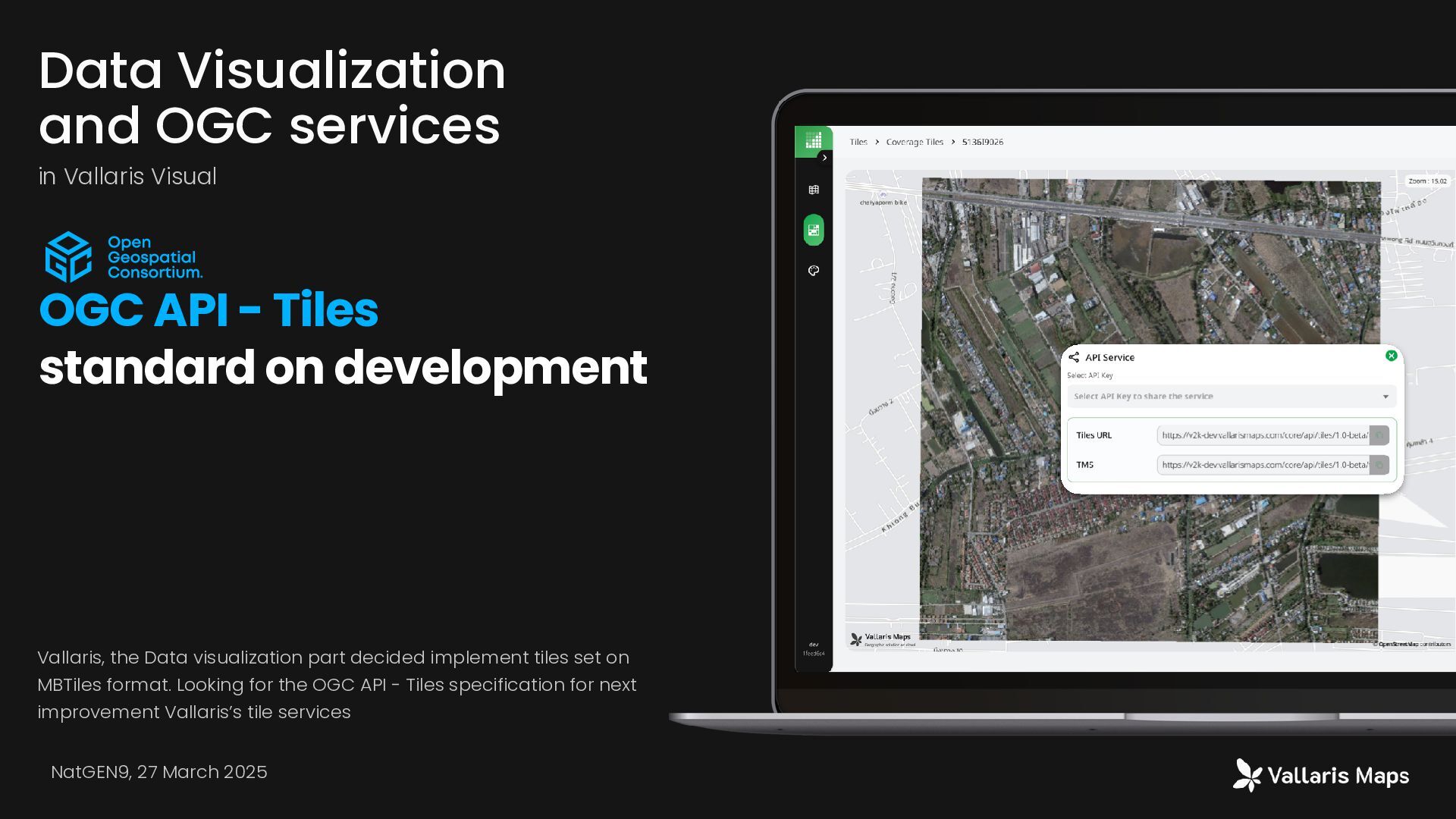
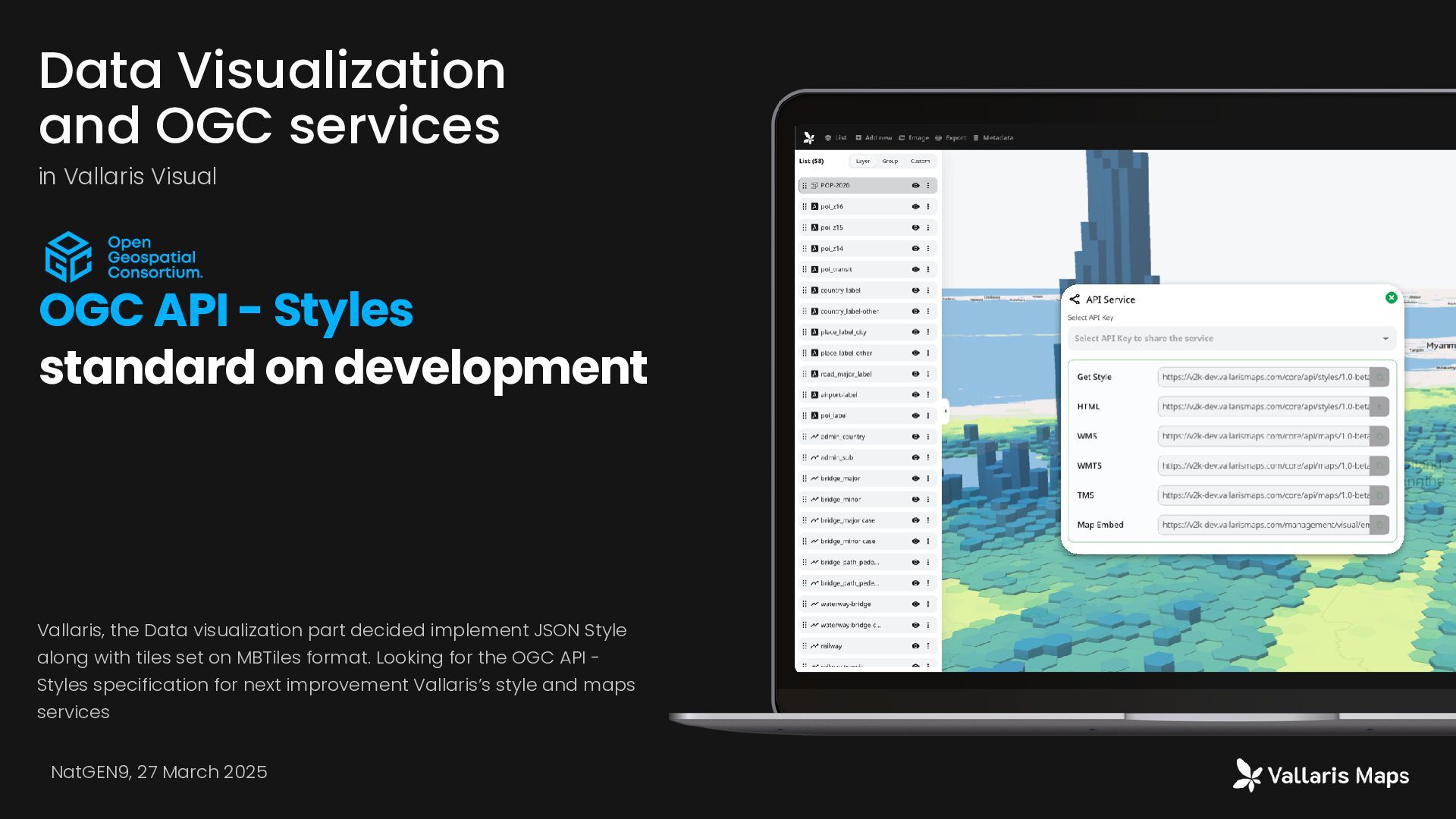
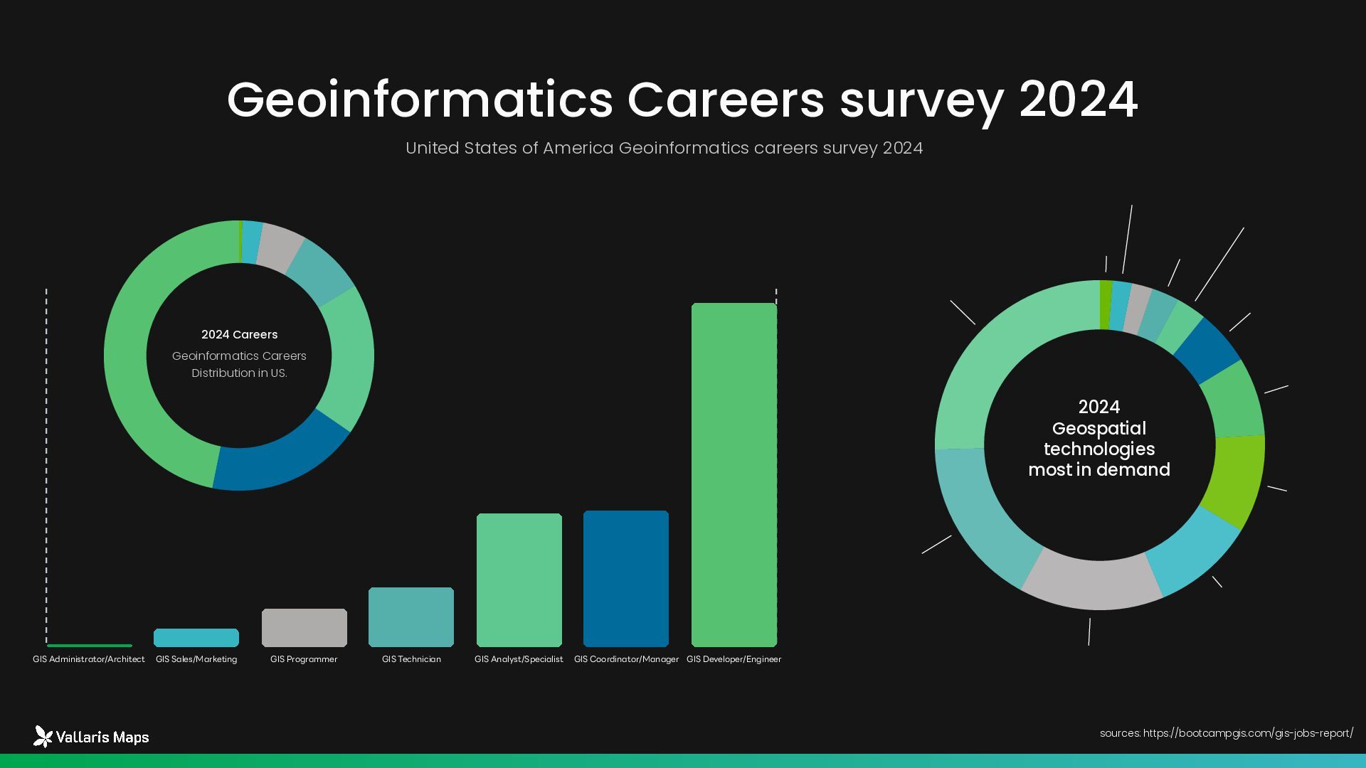
The evolving perspective of the geospatial information industry has transformed data usage requirements and consequently affected approaches to monitoring climate change across data dimensions, processing, and visualization. This presents a challenge for geospatial information system designers who must respond to these changes. The presentation content draws from experience in designing decision support systems for disaster area management at the Geo-Informatics and Space Technology Development Agency (GISTDA), incorporating modern geospatial information concepts. Additionally, it provides recommendations for adapting geospatial information professionals to align with the modern era.

Avatar for Prasong Patheepphoemphong

Prasong Patheepphoemphong

March 26, 2025
Tweet

More Decks by Prasong Patheepphoemphong

Other Decks in Technology

Transcript

  1. Prasong Patheepphoemphong chief executive officer at i-bitz company limited Perspectives

    on Modern Geoinformatics Concepts in Disaster Information มุมมองของแนวคิดภูมิสารสนเทศสมัยใหม่กับการบริหารจัดการข้อมูลภัยพิบัติ NatGEN9, 27 March 2025
  2. Introduction Our Company i-bitz, the geomatics company which has highly

    experienced in geoinformatic technology. We are reaching to provide inventive and innovative solutions to solve location problem related to geoinformatic technology. Vallaris is product from our experience more than 20 years
  3. • Traditional GIS dominance • Desktop-based solutions • Limited mobile

    adoption • Limited cloud processing 2014 - 2016 Market Evolution phase In the past 10 years, from 2014 to 2024, Thailand's geospatial technology industry has undergone significant changes, transitioning from traditional geographic information technology used on personal computers to collaborative work on large-scale computer networks. Similarly, with the increasing volume and diversity of geographic information data, the methods of management, access, and processing have become different from the past. As a result, modern geographic information systems must adapt to accommodate these changes, and we are seeing more modern geospatial platforms emerging. • Cloud transition begins • Mobile solutions emerge • Smart city initiatives start 2017 -2019 • Digital transformation acceleration • COVID-19 impact • Remote solutions demand 2020 - 2022 • Could Native geospatial • Cloud-base processing • Modern Geospatial platform • Real-time processing capability 2025 - Future • AI/ML integration • Platform consolidation • Metaverse emergence 2023 - 2024 sources: GISTDA annual reports, THEOS mission data, Ministry of Agriculture and Cooperatives, Department of Disaster Prevention and Mitigation, Royal Forest Department, Academic research publications, International space agency reports integration data by claude.ai
  4. Urban Planning Public Services Thailand Geospatial Market Segment by industry

    2023 20% 15% 25% 40% Agriculture Transportation • Smart City initiative • Land management • Infrastructure planning • Public safety • Environmental monitoring • Property development • Construction planning • Facility management • Market analysis • Precision farming • Crop monitoring • Yield optimization • Agricultural planning • Fleet management • Route optimization • Last-mile delivery • Infrastructure planning sources: Government budget allocation, Digital Economy Promotion Agency (DEPA), BOI incentives, Private sector investment, International cooperation projects
  5. • Smart City initiative • Land management • Infrastructure planning

    • Public safety • Environmental monitoring Thailand Geospatial Market Growth Segment by industry 2014 - 2024 • Property development • Construction planning • Facility management • Market analysis • Precision farming • Crop monitoring • Yield optimization • Agricultural planning • Fleet management • Route optimization • Last-mile delivery • Infrastructure planning 25% 17% 12% 18% Urban Planning Public Services Agriculture Transportation CAGR CAGR CAGR CAGR sources: Government budget allocation, Digital Economy Promotion Agency (DEPA), BOI incentives, Private sector investment, International cooperation projects
  6. The overall changes in technology have affected how Geographic Information

    Technology is perceived in the country. A significant change is that solutions must be able to address work requirements and process data on cloud computing systems. Technology Adoption Growth from 10% to 60% or 25% CAGR Cloud Solution Mobile Application AI ML Solution from 20% to 75% or 20% CAGR from minimal to 40% or 30% CAGR sources: GISTDA annual reports, THEOS mission data, Ministry of Agriculture and Cooperatives, Department of Disaster Prevention and Mitigation, Royal Forest Department, Academic research publications, International space agency reports integration data by claude.ai
  7. The increasing use of geographic information data has become more

    widespread in both government and private sectors. This is especially true for satellite data utilization and creating various benefits from the data in multiple formats. This is due to the increasing capabilities of satellites, both in terms of technological advancement and the growing number of satellites Data Volume Growth from 50TB to ~500TB or 25% CAGR Annual Overall Geospatial Data Usage Satellite Data Usage ~450TB in 2023 sources: GISTDA annual reports, THEOS mission data, Ministry of Agriculture and Cooperatives, Department of Disaster Prevention and Mitigation, Royal Forest Department, Academic research publications, International space agency reports integration data by claude.ai Government Budgeting in Satellite data from $5M to $25M or 400% CAGR Private Sector Budgeting in Satellite data from $2M to $15M or 650% CAGR
  8. Geospatial Data Processing shift. Larger FasterFrom Day to Week Become

    Hour to Day From Megabyte to Terabyte Power From local to Cloud computing
  9. The geospatial evolution from classic to modern geospatial software platform

    Desktop GIS Data on you local storage and limit on large scale processing, and publishing Internet Mapping Web 2.0 and 3.0 make mapping shift on the web based. immersive Mapping New devices to interact to data. Anytime AnyWhere
  10. Microservice Architecture Vallaris Maps has microservice architecture based, almost 100

    services support geospatial capability since basic to advance functions Modern Geospatial Standard FAIR principle is fundamental concept of software development. Vallaris Maps services and encoding standard are following the OGC Standard which OGC API series. Cloud Native Design More than Vallaris Maps 80% of services designed by using Cloud Native concept Which able to work on cloud providers. Modernize storage. GISTDA DISASTER Plarform is decision support system for disaster area management design by approaching modern information technology that integrated new technology such as cloud native design application and microservices architecture in our product. These brings our product scalable and flexible. Modern Geospatial Architecture Vallaris Maps and GISTDA disaster are approaching the modern geo.
  11. 01 02 03 17 Key Techniques in Cloud Native Geospatial

    Technology Data Storage and Management Techniques Object Storage Integration and Spatio-Temporal Asset Catalogs (STAC) Microservices Architecture The company has designed all system architecture in the form of Microservice, using 15 virtual machines... each virtual machine will have different functions API and Service Integration OGC-Compliant Services and RESTful API Implementation NatGEN9, 27 March 2025 on Vallaris and GISTDA Disaster Cloud native geospatial technology integrates object storage systems, spatio-temporal asset catalogs (STAC), containerized microservices, standardized OGC-compliant APIs, automated processing pipelines, and advanced spatial indexing methods. These interconnected techniques enable efficient management of large geospatial datasets, sophisticated querying capabilities, independent scaling of system components, standardized data access, automated processing workflows, and optimized spatial analysis - all working together to meet the performance demands of modern spatial applications.
  12. 04 05 06 18 Key Techniques in Cloud Native Geospatial

    Technology Processing and Analysis Techniques Pipeline Processing and H3 Spatial Indexing Performance and Security Measures Load Testing and Performance Optimization and Security Protocols Monitoring and Backup Systems Comprehensive Monitoring and Multi-level Backup Systems on Vallaris and GISTDA Disaster Cloud native geospatial technology integrates object storage systems, spatio-temporal asset catalogs (STAC), containerized microservices, standardized OGC-compliant APIs, automated processing pipelines, and advanced spatial indexing methods. These interconnected techniques enable efficient management of large geospatial datasets, sophisticated querying capabilities, independent scaling of system components, standardized data access, automated processing workflows, and optimized spatial analysis - all working together to meet the performance demands of modern spatial applications. NatGEN9, 27 March 2025
  13. The design is comprehensive system for disaster management that integrates

    geospatial data from multiple sources to produce specialized maps and indices. The system draws from GISTDA's image archives and other data repository to create flood maps, rainfall forecasts, hotspot detection, and other disaster-related visualizations through automated Python workflows. The architecture employs OGC standards and APIs for data discovery, processing, and storage, with a web application interface that allows users to view current and historical disaster data, access predictions, and analyze provincial disaster information. The system emphasizes standardized data communication pathways to support both internal analysis and external system integration. Conceptual Design NatGEN9, 27 March 2025
  14. The GISTDA Processing Engine is a sophisticated geospatial data processing

    system for disaster management that consists of nine specialized pipelines handling different disaster types. Pipelines process satellite imagery and environmental data for 1. FLOOD (using a two-tier R1/R2 approach) 2. FOREST FIRE(analyzing burn areas from Sentinel-2 and Landsat imagery), 3. DROUGHT (processing soil moisture, precipitation, and drought indices). Built on modern cloud-native architecture using Kubernetes for orchestration, the system integrates with MongoDB and S3 storage while exposing processed data through standardized REST APIs. The engine follows efficient workflows from data ingestion through processing to data transformation and storage, delivering critical geospatial intelligence to support disaster monitoring and decision-making with demonstrated capacity to handle 300 concurrent users while maintaining responsive performance metrics. Processing Engine NatGEN9, 27 March 2025
  15. Flood Data Sources and Processing How data processing in each

    data source? Sentinel-1 satellite imagery Rainfall data Rainfall forecast data Hyacinth area data R1 flood area processing Processing flood area data from Sentinel-1 satellite and automatic process to get flood areas R2 flood area processing Takes R1 data for accuracy verification Rainfall data processing Download real-time (every 1 hour), 1-day and 7-day historical Rainfall forecast processing Real-time format every day at 06:00 UTC and 13:00 Thailand time Temporal aggregation processing flood data is processed into 1-day, 3-day, 7-day, and 30-day Data Sources Processing Method NatGEN9, 27 March 2025
  16. Forest Fire Sources and Processing How data processing in each

    data source? Hotspot data from VIIRS satellite Burn scar data Burn frequency data Daily hotspot data processing The hotspot data storage system has been connected to the database, receiving data in daily format, and has developed data processing Temporal aggregation processing Additional pipelines process data into 3-day, 7-day, and 30-day historical view Burn scar and frequency processing Processing of Landsat 8-9 satellite fire area data Processing of Sentinel-2 satellite burn scar area data Data Sources Processing Method NatGEN9, 27 March 2025
  17. Drought Data Sources and Processing How data processing in each

    data source? Drought Risk Index Plus (DRI+) Soil Moisture Active Passive (SMAP) Normalized Difference Water Index (NDWI) Land Surface Temperature (LST) Normalized Difference Vegetation Index (NDVI) H3 spatial indexing H3 is a spatial index and a hierarchical grid system designed for displaying spatial data, which divides the earth's surface into hexagonal cells Drought Risk Index processing Module calling data from database and processing to make the data in H3 formatRainfall data processing Soil Moisture processing Weekly and 15-day processing pipelines Vegetation Moisture processing Processing of NDWI vegetation moisture average value data Data Sources Processing Method
  18. 01 02 03 04 24 General Processing Pattern Processing the

    data on Cloud Computing Pipeline Automation All data types use scheduled, automated processing pipelines "Pipeline workflow in 2 forms: Manual processing Pipeline and Automatic processing Pipeline Data Transformation Conversion to standardized formats (Features Collection, Coverage Collection) Tile generation for efficient visualization STAC Catalog Organization of data into standardized Spatio- Temporal Asset Catalogs Creation of aggregated views (1-day, 3-day, 7-day, 30-day) API Services Creation of standardized access methods for each dataset "API Stack is the provision of data in the form of REST API" This comprehensive approach to data sourcing and processing enables the platform to provide timely, accurate information for disaster management decision support, with each disaster type having specialized processing flows tailored to its unique data characteristics and requirements. NatGEN9, 27 March 2025
  19. "The system provides geospatial information services on floods, wildfires, and

    droughts, presenting an overview of the latest disaster situations in Thailand. Users can also view online maps by themselves according to specific time periods. Those who have registered as members can download various data files and receive an API Key to retrieve geospatial data using the API Service." GISTDA disaster.gistda.or.th Decision support system for disaster area management NatGEN9, 27 March 2025
  20. STAC Structure design STAC enables efficient querying based on both

    location and time periods, which is crucial for disaster monitoring applications. As implemented in the documented platform, STAC structures are customized for different disaster types (fire, flood, drought), organizing data by time periods, processing stages, and data sources. The standard uses REST API endpoints to allow applications to discover and access geospatial data programmatically. This approach ensures interoperability between different systems while providing the flexibility to accommodate various data types and sources, making it a foundational component of modern cloud-native geospatial architectures. FLOOD Data on STAC structure for accessibility
  21. Legacy GIS deployment system How data processing in each data

    source? Single-machine deployment Multitiered deployment Highly available deployment NatGEN9, 27 March 2025
  22. September 2021, Vallaris has officially approved by OGC in standard

    calls OGC API - FEATURES PART 1 - CORE and PART 2 - CRS by Reference. The OGC API - FEATURES is one of family of standards are being developed to make it easy for anyone to provide geospatial data to the web. This is first step to become standard software. More and more features will create for next standard Data Management and OGC services in Vallaris Data Store OGC API - Features (Part 1,2 and 4) NatGEN9, 27 March 2025
  23. Vallaris data Store version 1.4.5 was support coverage data and

    trying follow the OGC API - Coverages specification. On this released Vallaris is able to provide API services in coverage json encoding and which linked to resource. Data Management and OGC services in Vallaris Data Store OGC API - Coverages Service in CovJSON Stored in COG and thumbnail NatGEN9, 27 March 2025
  24. Vallaris data Store version 1.4.5 was support asynchronous online web

    processing. Process has using python programming language covered by OGC - API Processes Part 1 : Core. An additional the Process deployment and Process workflow are using in Vallaris in several project. Data Manipulation and OGC services in Vallaris Process OGC API - Processes (Part 1,2 and 3) NatGEN9, 27 March 2025
  25. Data Manipulation and OGC services in Vallaris Process OGC API

    - Processes (Part 1,2 and 3) Vallaris data Store version 1.4.5 was support asynchronous online web processing. Process has using python programming language covered by OGC - API Processes Part 1 : Core. An additional the Process deployment and Process workflow are using in Vallaris in several project. NatGEN9, 27 March 2025
  26. Vallaris, the Data visualization part decided implement tiles set on

    MBTiles format. Looking for the OGC API - Tiles specification for next improvement Vallaris’s tile services Data Visualization and OGC services in Vallaris Visual OGC API - Tiles standard on development NatGEN9, 27 March 2025
  27. Data Visualization and OGC services in Vallaris Visual OGC API

    - Tiles standard on development Vallaris, the Data visualization part decided implement tiles set on MBTiles format. Looking for the OGC API - Tiles specification for next improvement Vallaris’s tile services NatGEN9, 27 March 2025
  28. Data Visualization and OGC services in Vallaris Visual OGC API

    - Styles standard on development Vallaris, the Data visualization part decided implement JSON Style along with tiles set on MBTiles format. Looking for the OGC API - Styles specification for next improvement Vallaris’s style and maps services NatGEN9, 27 March 2025
  29. The additional or top-up services on OGC API - Coverages

    is OGC API - EDR. EDR are set of services from Vallaris Maps on coverage data store. GISTDA Dragonfly project is using OGC API - Coverages and OGC API - EDR in agriculture use case. ** OGC API - EDR has wide capacity on spatial and time which this project using only 2D Spatial and Time ** ** Interesting in term of implementation, We are approaching single temporal coverage data while solve temporal issue by STAC and STAC API ** Data Retrieval and OGC services in Vallaris API level OGC API - ENVIRONMENTAL DATA RETRIEVAL NatGEN9, 27 March 2025
  30. Vallaris 1.4.5 has capacity to ingest, store and retrieve STAC

    metadata. By retrieval STAC via STAC API 1.0 We using STAC and STAC API in GISTDA project, held all archive satellite imagery for internal use and sale imagery for external. We have tried make create STAC for vector data in some project. STAC and STAC API are metadata when need to organize spatial and temporal data. Data Retrieval and STAC API in Vallaris API level STAC and STAC API NatGEN9, 27 March 2025
  31. The overall workforce landscape in the market Geospatial Workforce landscape

    sources: Tool, toolmaker, and scientist: case study experiences using GIS in interdisciplinary research https://www.tandfonline.com/doi/full/10.1080/15230406.2020.1748113 Tools User GIS Analyst GIS Technician Tools Maker GIS Web and Mobile App Builder GIS Specialist GeoSpatial Scientist Breadth of GIS domain knowledge Number of Workforce Depth of Expertise The overall workforce landscape in the job market aligns with this representation, where the group of GIS tool users is significantly larger than the tool makers, and the smallest group is the data analysts. When considering the level of expertise and the depth of spatial knowledge utilization, the workforce quantity continues to decrease as the level of specialization increases.
  32. Work force Skill and Project complexity has been change over

    the years since 2014 to 2024 Skill & Complexity Distribution Change Most are Traditional GIS professional 2014 Skill Distribution Growing on Geospatial programming and Geospatial Data Scientist 2024 Skill Distribution Basic Mapping project are majority in the solutions 2014 Complexity Solution become more advance analysis and Integration solution 2024 Complexity Skill 2014 Programming 20% Data Scientist 20% Traditional GIS 60% sources: GISTDA annual reports, THEOS mission data, Ministry of Agriculture and Cooperatives, Department of Disaster Prevention and Mitigation, Royal Forest Department, Academic research publications, International space agency reports integration data by claude.ai Programming 35% Data Scientist 35% Traditional GIS 30% Skill 2024 Advance Analysis 30% Integration 20% Basic Mapping 50% Project 2014 Advance Analysis 40% Integration 40% Basic Mapping 20% Project 2024
  33. GIS Administrator/Architect GIS Sales/Marketing GIS Programmer GIS Technician GIS Analyst/Specialist

    GIS Coordinator/Manager GIS Developer/Engineer 8,636 3,423 3,362 1,509 981 455 70 United States of America Geoinformatics careers survey 2024 Geoinformatics Careers survey 2024 sources: https://bootcampgis.com/gis-jobs-report/ 47% 19% 18% 8% 5% 2% Geoinformatics Careers Distribution in US. 2024 Careers Data Science 25% Image Processing/Remote Sensing 17% Modeling 14% LiDAR 10% Python 10% Land Survey 8% Google Cloud 5% Photogrammetry 3% HTML 3% AWS 2% UAV/UAS/Drone 2% BIM 1% 2024 Geospatial technologies most in demand
  34. If you have any question, Feel free to contact us

    any time on (phone cell) or contact us by (email). We will get back to you as soon as we can Location 1371 Suite10 Capital Mansion Phahonyothin Rd Phayathai Bangkok 10400 Office Hours Monday-Friday 09.00-17.00 Get In Touch (+66) 2278 7913 (+66) 186666 4624 More Information vallarismaps.com [email protected] Contact Us Company