Upgrade to Pro
— share decks privately, control downloads, hide ads and more …
Speaker Deck
Sign up for free
Menu
Search
Features
All features
Private URLs
Password Protection
Custom URLS
Scheduled publishing
Remove Branding
Restrict embedding
Deck Collections
Notes
Features
All features
Private URLs
Password Protection
Custom URLS
Scheduled publishing
Remove Branding
Restrict embedding
Deck Collections
Notes
Explore
Featured decks
Featured speakers
Programming
Technology
Storyboards
Explore
Featured decks
Featured speakers
Programming
Technology
Storyboards
Pricing
Search
Sign in
Sign up for free
ZFXY: a 3D spatio-temporal tiling scheme propos...
Search
Hidenori FUJIMURA
March 16, 2022
Technology
340
0
Share
Embed
Copy iframe code
Copy JS code
Copy link
Start on current slide
ZFXY: a 3D spatio-temporal tiling scheme proposal for optimized data access
UN Open GIS Initiative Monthly VTC, 2022-03
Hidenori FUJIMURA
March 16, 2022
More Decks by Hidenori FUJIMURA
See All by Hidenori FUJIMURA
みんなに伝わる防災マップ
hfu
0
180
未来の繁栄のためのスマート地図
hfu
0
210
Smart Maps for the prosperity in the future
hfu
0
300
Smart Maps and Bazaar
hfu
0
230
Sensemaking with Smart Maps
hfu
0
160
Smart Maps for the United Nations, with the United Nations
hfu
0
210
UN Smart Maps
hfu
0
250
スマート地図バザールによる地図XMLのタイル配信
hfu
0
150
国土地理院におけるベース・レジストリの整備とDX推進への取り組み
hfu
0
360
Other Decks in Technology
See All in Technology
FinOps Agentが生んだ技術負債:コスト自動調査の落とし穴と解消までの道のり
oasis1994liveforever
3
300
LLM-as-a-Judgeは本当に信頼できるのか――評価器を評価する話
taka_aki
3
1.1k
撮るだけでは終わらない。ソニーが挑むB2Bカメラソリューション開発
sony
0
110
アカウント統制の健康診断
kenichinakamura
1
200
自宅サーバと脆弱性
masakiokuda
1
120
Claude Code on Bedrock で統制をかける小ネタ集/claude-code-bedrock-governance-tips
emiki
1
13k
LLM Content Moderationを支える評価・改善ループの実践
suikabar
2
360
背中から、背中へ ー 社外コミュニティで学んだ「雑に背中を押す」という恩送り ー / easygoing encouragement and pay forward to community
naitosatoshi
0
330
2026-10-24 JAWS JAWS-UG 茨城 #18 IAM Policy Autopilotってなにさ。terraform planからIAM Policyつくれるの? / What's IAM Policy Autopilot
masasuzu
0
170
Codex を使った障害対応机上演習の実際
orgachem
PRO
0
360
「私が一番顧客に詳しい」を捨てる~ 全員が一次情報に精通する開発チームをつくり、PMが次のボトルネックへ染み出すまで
kaminashi
4
2.5k
Claude Code をローカルとサーバー上で利用した際の Bedrock 利用料をユーザー単位で一本化してみる
ohorig
0
160
Featured
See All Featured
Visualization
eitanlees
153
17k
StorybookのUI Testing Handbookを読んだ
zakiyama
31
7k
Highjacked: Video Game Concept Design
rkendrick25
PRO
1
490
A brief & incomplete history of UX Design for the World Wide Web: 1989–2019
jct
2
540
Why You Should Never Use an ORM
jnunemaker
PRO
61
10k
XXLCSS - How to scale CSS and keep your sanity
sugarenia
250
1.3M
The #1 spot is gone: here's how to win anyway
tamaranovitovic
4
1.2k
Technical Leadership for Architectural Decision Making
baasie
3
610
Stop Working from a Prison Cell
hatefulcrawdad
274
21k
The Web Performance Landscape in 2024 [PerfNow 2024]
tammyeverts
12
1.3k
A Tale of Four Properties
chriscoyier
163
24k
Evolution of real-time – Irina Nazarova, EuRuKo, 2024
irinanazarova
9
1.6k
Transcript
ZFXY: a 3D spatio-temporal tiling scheme proposal for optimized data
access Hidenori (UN Vector Tile Toolkit / Geospatial Information Authority of Japan)
Introduction of background: 3D geospatial projects in Japan
GSI secured budget for point cloud data (regular budget [2
million USD] + external supplementary budget)
Shizuoka Prefecture is completing provision of point cloud data as
Open Data
City Bureau of MLIT has been leading 3D city modeling
throuh Project PLATEAU
Tokyo Metropolitan Government started Tokyo Digital Twin Project
3D Spatial Information Infrastructure project led by Ministry of Economy,
Trade, and Industry / IPA DADC
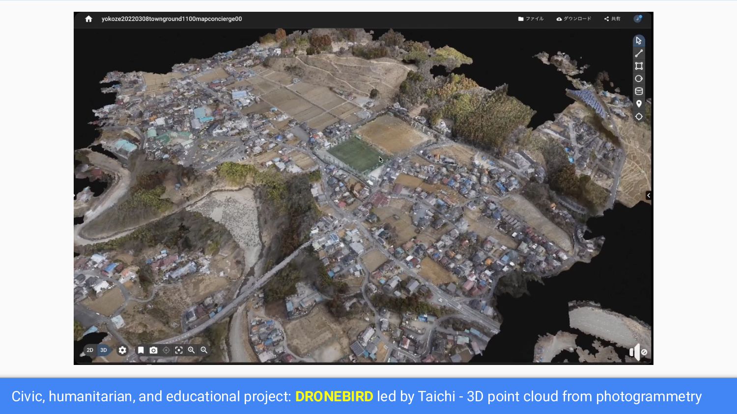
Civic, humanitarian, and educational project: DRONEBIRD led by Taichi -
3D point cloud from photogrammetry
Our UNVT colleague Takayuki appointed in 3D spatial information infrastructure
design committee by IPA DADC.
UNVT Community is working on: How can we optimize access
to 3D geospatial data?
Tile: industry standard in web maps {z}/{x}/{y} z: zoom index,
x: west-east index, y: north-south index
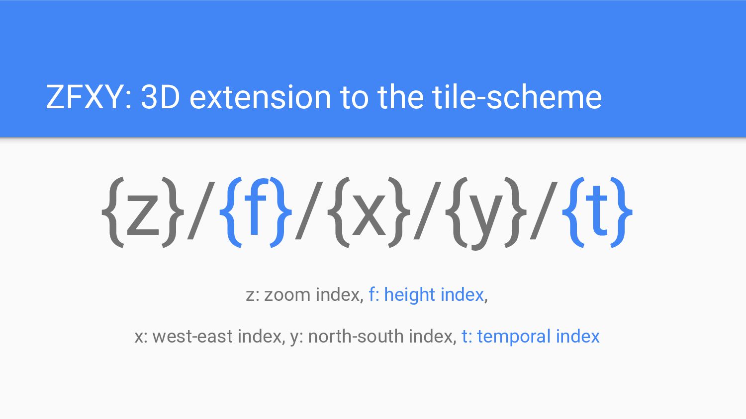
ZFXY: 3D extension to the tile-scheme {z}/{f}/{x}/{y} z: zoom index,
f: height index, x: west-east index, y: north-south index
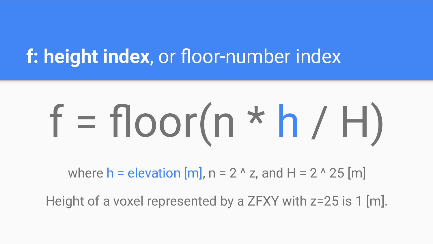
f: height index, or floor-number index f = floor(n *
h / H) where h = elevation [m], n = 2 ^ z, and H = 2 ^ 25 [m] Height of a voxel represented by a ZFXY with z=25 is 1 [m].
https://github.com/unvt/zfxy-spec
https://github.com/unvt/zfxy-ruby
Demo
https://unvt.github.io/zfxy-ruby/
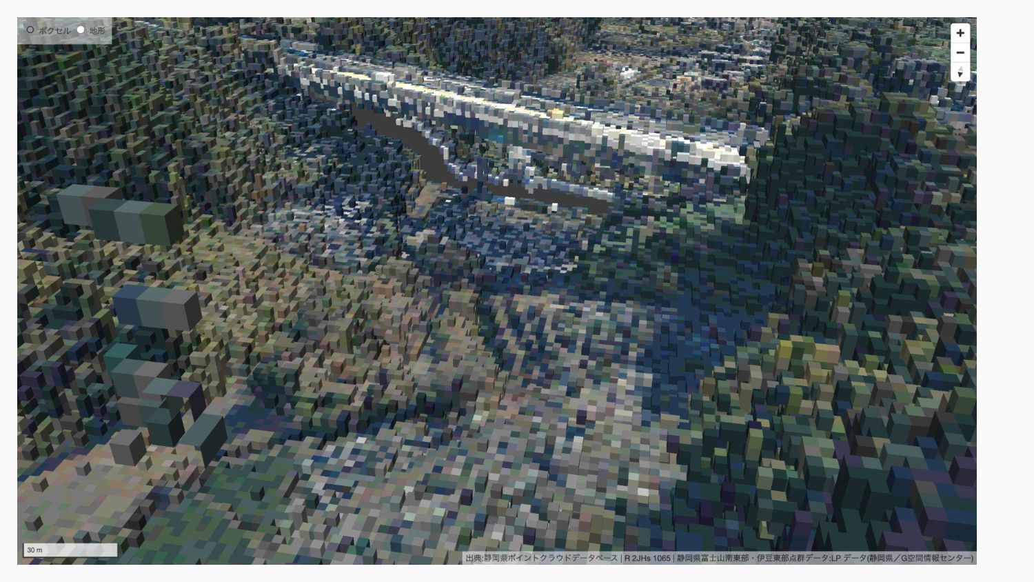
50cm GSD at z=26 https://x.optgeo.org/zfxy-ruby/#22.28/35.65779459/139.70209432/-85.5/60
https://geolonia.github.io/zfxy/#8.14/35.431/138.612/-45.6/60
https://github.com/geolonia/zfxy
Temporal extension
ZFXY: 3D extension to the tile-scheme {z}/{f}/{x}/{y}/{t} z: zoom index,
f: height index, x: west-east index, y: north-south index, t: temporal index
t: temporal index, or pomodoro code Time.now.to_i / 1800
Motivation of UNVT Community to join We need data to
prove the value of ZFXY. We are happy to build prototypes with your data.
None
None


 hfu
 oasis1994liveforever
 taka_aki
 sony
 kenichinakamura
 masakiokuda
 emiki
 suikabar
 naitosatoshi
 masasuzu
 orgachem
 kaminashi
 ohorig
 eitanlees
 zakiyama
 rkendrick25
 jct
 jnunemaker
 sugarenia
 tamaranovitovic
 baasie
 hatefulcrawdad
 tammyeverts
 chriscoyier
 irinanazarova